

45498 W Carver Rd Tonopah, AZ 85354
Estimated payment $531/month
Total Views
626
40
Acres
$2,370
Price per Acre
1,745,014
Sq Ft Lot
Highlights
- Horses Allowed On Property
- No HOA
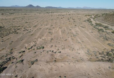
- Level Lot
- 40.06 Acre Lot
About This Lot
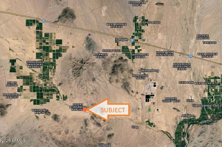
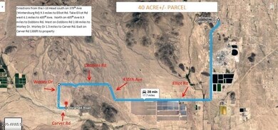
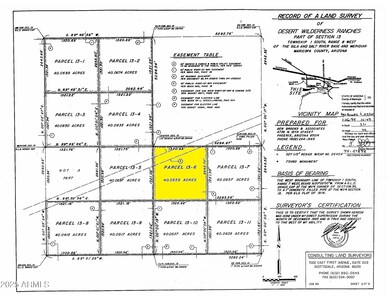
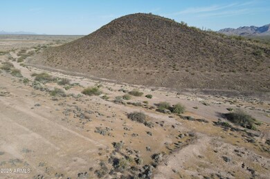
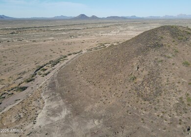
JUST OVER 40 ACRES LOCATED IN DESERT WILDERNESS RANCHES, WEST OF PHOENIX IN TONOPAH, AZ! PANORAMIC VIEWS OF SADDLE AND EAGLE TAIL MOUNTAINS. POWER RUNS ALONG CARVER RD. PERFECT LOCATION FOR THOSE WHO PREFER OFF THE BEATEN PATH AND RURAL WESTERN LIVING OR GREAT OPPORTUNITY TO POSSIBLY SUB-DIVIDE INTO SMALLER PARCELS. ZONED R-190. MARICOPA COUNTY APN 401-52-022. *BUYER TO VERIFY SCHOOLS, ZONING / USE, UTILITIES, ACCESS & ALL PERTINENT INFORMATION. DIRECTIONS: I-10/379TH AVE (WINTERSBURG RD) - S ON WINTERSBURG RD 9.3M TO ELLIOT, W ON ELLIOT 6.1 M TO 435TH AVE, N ON 435TH AVE .9 M TO DOBBINS, W ON DOBBINS 2.88M TO WORLEY DR, S ON WORLEY 1.5M TO CARVER RD, E ON CARVER RD ¾ MILE TO NE CORNER OF PARCEL. DONT USE ADDRESS TO LOCATE MUST USE AERIAL MAPS & GPS COORD 33.339270, -113.028876.
Property Details
Property Type
- Land
Est. Annual Taxes
- $20
Lot Details
- 40.06 Acre Lot
- Level Lot
- Property is zoned R-190
Schools
- Arlington Elementary School
Horse Facilities and Amenities
- Horses Allowed On Property
Community Details
- No Home Owners Association
- Desert Wilderness Ranches Subdivision
Listing and Financial Details
- Assessor Parcel Number 401-52-022
Map
Create a Home Valuation Report for This Property
The Home Valuation Report is an in-depth analysis detailing your home's value as well as a comparison with similar homes in the area
Home Values in the Area
Average Home Value in this Area
Tax History
| Year | Tax Paid | Tax Assessment Tax Assessment Total Assessment is a certain percentage of the fair market value that is determined by local assessors to be the total taxable value of land and additions on the property. | Land | Improvement |
|---|---|---|---|---|
| 2025 | $20 | $240 | $240 | -- |
| 2024 | $20 | $278 | $278 | -- |
| 2023 | $20 | $6,180 | $6,180 | $0 |
| 2022 | $19 | $4,245 | $4,245 | $0 |
| 2021 | $19 | $240 | $240 | $0 |
| 2020 | $21 | $240 | $240 | $0 |
| 2019 | $21 | $240 | $240 | $0 |
| 2018 | $26 | $300 | $300 | $0 |
| 2017 | $31 | $360 | $360 | $0 |
| 2016 | $36 | $421 | $421 | $0 |
| 2015 | $39 | $449 | $449 | $0 |
Source: Public Records
Property History
| Date | Event | Price | Change | Sq Ft Price |
|---|---|---|---|---|
| 04/10/2025 04/10/25 | Pending | -- | -- | -- |
| 03/03/2025 03/03/25 | For Sale | $94,947 | -- | -- |
Source: Arizona Regional Multiple Listing Service (ARMLS)
Deed History
| Date | Type | Sale Price | Title Company |
|---|---|---|---|
| Warranty Deed | $105,000 | Pioneer Title Agency |
Source: Public Records
Similar Properties in Tonopah, AZ
Source: Arizona Regional Multiple Listing Service (ARMLS)
MLS Number: 6829440
APN: 401-52-022
Disclaimer: Certain information contained herein is derived from information provided by parties other than Homes.com. All information provided is deemed reliable, but is not guaranteed to be accurate and should be independently verified.
![]() All information should be verified by the recipient and none is guaranteed as accurate by ARMLS
All information should be verified by the recipient and none is guaranteed as accurate by ARMLS
Listing Information presented by local MLS brokerage: Ten-X, local REALTOR®- Arlene Richardson - (888)-952-6393
Nearby Homes
- 00 S 455th Ave Unit 13-10
- 00 S 450th Ave Unit 1
- 467XX W Elliot Rd
- 38XXX W Elliot Rd
- 538XX W Elliot Rd
- 0 W Narramore Road and 435th Ave
- 0 S 7w -- Unit 19-8 6756867
- xxxxx S 435th Ave
- xxxxxx S 435th Ave
- xx S 435th Ave
- xxx S 435th Ave
- xxxx S 435th Ave
- 0 W Elliot Rd Unit 6654706
- 47700 appx W Narramore Rd
- 0 W Narramore Rd Unit 80 6791176
- 0 S 418th Ave Unit 6791462
- 0 S 418th Ave
- 165XX S Burger St Unit 22
- 0 W Dobbins Road and 399th Ave -- Unit 6638244
- 0 W Western Star Blvd Blvd Unit 338 6830183