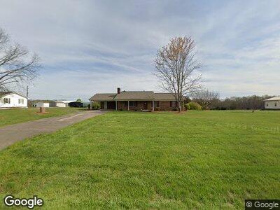
5038 Harmon Rd Kings Mountain, NC 28086
Estimated Value: $293,000 - $2,436,000
--
Bed
--
Bath
1,791
Sq Ft
$512/Sq Ft
Est. Value
About This Home
This home is located at 5038 Harmon Rd, Kings Mountain, NC 28086 and is currently estimated at $916,420, approximately $511 per square foot. 5038 Harmon Rd is a home located in Cleveland County with nearby schools including Bethware Elementary School, Kings Mountain Intermediate School, and Kings Mountain Middle.
Ownership History
Date
Name
Owned For
Owner Type
Purchase Details
Closed on
Feb 21, 2025
Sold by
Carrigan Betty H and Cb Of Km Llc
Bought by
Automotive Recovery Services Inc
Current Estimated Value
Purchase Details
Closed on
Oct 12, 2017
Sold by
Cb Of Km Llc
Bought by
Carrigan Charles A and Carrigan Betty H
Purchase Details
Closed on
May 11, 2017
Sold by
Carrigan Charles A and Carrigan Betty H
Bought by
Cb Of Km Llc
Create a Home Valuation Report for This Property
The Home Valuation Report is an in-depth analysis detailing your home's value as well as a comparison with similar homes in the area
Home Values in the Area
Average Home Value in this Area
Purchase History
| Date | Buyer | Sale Price | Title Company |
|---|---|---|---|
| Automotive Recovery Services Inc | $3,725,000 | Harbor City Title | |
| Automotive Recovery Services Inc | $3,725,000 | Harbor City Title | |
| Carrigan Charles A | -- | None Available | |
| Cb Of Km Llc | -- | None Available |
Source: Public Records
Tax History Compared to Growth
Tax History
| Year | Tax Paid | Tax Assessment Tax Assessment Total Assessment is a certain percentage of the fair market value that is determined by local assessors to be the total taxable value of land and additions on the property. | Land | Improvement |
|---|---|---|---|---|
| 2024 | $2,498 | $386,601 | $240,712 | $145,889 |
| 2023 | $2,085 | $386,602 | $240,713 | $145,889 |
| 2022 | $2,034 | $387,059 | $241,170 | $145,889 |
| 2021 | $2,044 | $387,059 | $241,170 | $145,889 |
| 2020 | $1,771 | $324,670 | $216,552 | $108,118 |
| 2019 | $1,771 | $324,670 | $216,552 | $108,118 |
| 2018 | $1,767 | $324,670 | $216,552 | $108,118 |
| 2017 | $1,993 | $324,670 | $216,552 | $108,118 |
| 2016 | $1,866 | $329,002 | $220,884 | $108,118 |
| 2015 | $1,919 | $332,691 | $220,884 | $111,807 |
| 2014 | $1,919 | $332,691 | $220,884 | $111,807 |
Source: Public Records
Map
Nearby Homes
- 5067 E Dixon Blvd
- 5139 E Dixon Blvd
- 118 Maple Crest Dr
- 2167 Vestibule Church Rd Unit 5U, 16U
- 111 Peoria Ln
- 2207 David Baptist Ch Rd
- 107 Stony Point Rd
- 317 Long Branch Rd
- 103 Stony Point Rd
- TBD Commerce Blvd
- 000 Hoyles Rd Unit 167
- 107 Plumtree Dr
- 2033 Shelby Rd
- 822 Bethlehem Rd
- 932 Long Branch Rd
- 907 Bethlehem Rd
- 143 Phifer Cir
- 103 Crown Ct
- 102 Heatherton Ln
- 105 Crown Ct