
51800 Highway 190 Cedar Slope, CA 93265
About This Lot
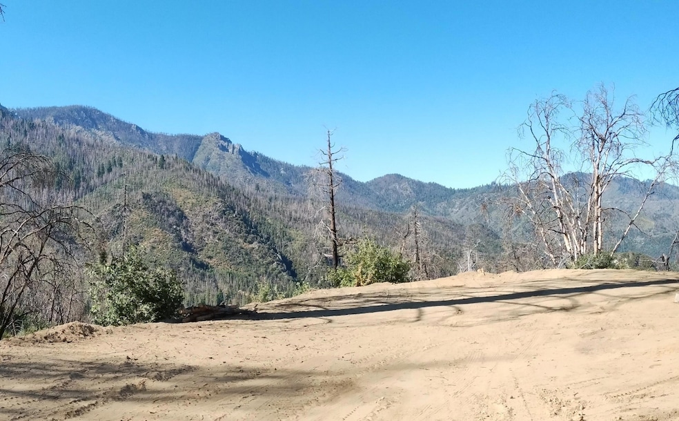
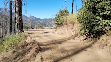
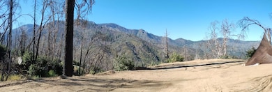
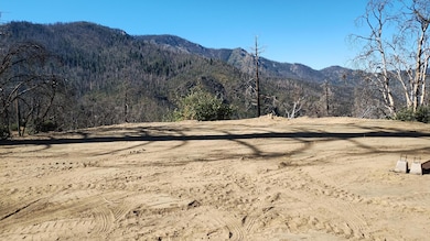
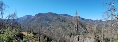
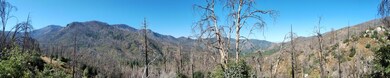
As of March 2025Looking for a semi-off-grid property with lots of privacy? This 1.66 acre lot has a great building area and mountain views in nearly every direction! Located just below Cedar Slope on a shared private driveway, McIntyre Creek runs on the edge of the property so you can hear and see the creek from the newly graded building area. The Castle Fire burned through this area but the upside is there is now close to a 360 degree view of the mountains. The property is adjacent to the national forest so it provides lots of privacy and a mountain feel. There is access to water from McIntyre Creek (needs to be reestablished due to fire damage) and a power pole nearby but you also have the option of going off grid if you prefer. If you are looking to build a vacation home on the mountain, this lot could be the one for you -- call today!
NOTE: The driveway is not plowed in the winter and the water system is not designed to be used in the winter. Property was in escrow but buyer failed to perform. Escrow is opened with Ann Kay at First American.
Property Details
Property Type
- Land
Est. Annual Taxes
- $185
Year Built
- 1900
Lot Details
- 1.66 Acre Lot
- Property fronts a highway
Property Views
- Mountain
- Forest
Community Details
- No Home Owners Association
Listing and Financial Details
- Assessor Parcel Number 220090002000
Map
Home Values in the Area
Average Home Value in this Area
Property History
| Date | Event | Price | Change | Sq Ft Price |
|---|---|---|---|---|
| 03/28/2025 03/28/25 | Sold | $32,000 | -17.9% | -- |
| 03/20/2025 03/20/25 | Pending | -- | -- | -- |
| 03/01/2025 03/01/25 | For Sale | $39,000 | +151.6% | -- |
| 02/28/2019 02/28/19 | Sold | $15,500 | -32.6% | -- |
| 02/08/2019 02/08/19 | Pending | -- | -- | -- |
| 04/03/2018 04/03/18 | For Sale | $23,000 | -- | -- |
Tax History
| Year | Tax Paid | Tax Assessment Tax Assessment Total Assessment is a certain percentage of the fair market value that is determined by local assessors to be the total taxable value of land and additions on the property. | Land | Improvement |
|---|---|---|---|---|
| 2024 | $185 | $16,950 | $16,950 | -- |
| 2023 | $186 | $16,618 | $16,618 | $0 |
| 2022 | $179 | $16,293 | $16,293 | $0 |
| 2021 | $177 | $15,974 | $15,974 | $0 |
| 2020 | $174 | $15,810 | $15,810 | $0 |
| 2019 | $118 | $10,541 | $10,541 | $0 |
| 2018 | $117 | $10,334 | $10,334 | $0 |
| 2017 | $115 | $10,131 | $10,131 | $0 |
| 2016 | $111 | $9,932 | $9,932 | $0 |
| 2015 | $107 | $9,783 | $9,783 | $0 |
| 2014 | $107 | $9,591 | $9,591 | $0 |
Deed History
| Date | Type | Sale Price | Title Company |
|---|---|---|---|
| Grant Deed | $32,000 | First American Title Company | |
| Grant Deed | $15,500 | Chicago Title Co | |
| Interfamily Deed Transfer | -- | -- | |
| Interfamily Deed Transfer | -- | -- |
Source: Tulare County MLS
MLS Number: 233780
APN: 220-090-002-000
Disclaimer: Certain information contained herein is derived from information provided by parties other than Homes.com. All information provided is deemed reliable, but is not guaranteed to be accurate and should be independently verified.
![]() Based on information from the Tulare County Association of REALTORS®. All data, including all measurements and calculations of area, is obtained from various sources and has not been, and will not be, verified by broker or MLS. All information should be independently reviewed and verified for accuracy. Properties may or may not be listed by the office/agent presenting the information.
Based on information from the Tulare County Association of REALTORS®. All data, including all measurements and calculations of area, is obtained from various sources and has not been, and will not be, verified by broker or MLS. All information should be independently reviewed and verified for accuracy. Properties may or may not be listed by the office/agent presenting the information.
- 0 Highway 190 Unit 224294
- 0 Cow Mountain Rd Unit 227866
- 0 Cow Mountain Rd Unit 227863
- 0 Cow Mountain Rd Unit 227861
- 0 Cow Mountain Rd Unit 227860
- 54569 Manzanita Dr
- 54584 Ponderosa Dr
- 206 Cedar Dr
- 159 Manzanita Ct
- 184 Manzanita Ct
- 720 Highway 190
- 305 John Lewis Dr
- 40267 Bear Creek Rd
- 40267 Bear Creek Dr
- 38641 Balch Park Rd
- 1184 Highway 190
- 37970 Balch Park Rd
- 1230 Wy Ct
- 0 Bourbon Dr
- 52762 Redwood Dr