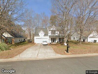
528 Saddlebrook Dr Rock Hill, SC 29730
Catawba NeighborhoodEstimated Value: $370,000 - $382,000
3
Beds
3
Baths
1,922
Sq Ft
$195/Sq Ft
Est. Value
About This Home
This home is located at 528 Saddlebrook Dr, Rock Hill, SC 29730 and is currently estimated at $375,649, approximately $195 per square foot. 528 Saddlebrook Dr is a home located in York County with nearby schools including Castle Heights Middle School, Rock Hill High School, and St. Anne Catholic School.
Ownership History
Date
Name
Owned For
Owner Type
Purchase Details
Closed on
Apr 22, 2009
Sold by
Holloway Christy M and Matkovich Christy Holloway
Bought by
Surig Thomas W
Current Estimated Value
Home Financials for this Owner
Home Financials are based on the most recent Mortgage that was taken out on this home.
Original Mortgage
$111,500
Outstanding Balance
$71,986
Interest Rate
4.86%
Mortgage Type
Unknown
Estimated Equity
$303,663
Purchase Details
Closed on
Mar 8, 2006
Sold by
Matkovich Christy Holloway and Matkovich Michael
Bought by
Matkovich Christy Holloway
Home Financials for this Owner
Home Financials are based on the most recent Mortgage that was taken out on this home.
Original Mortgage
$20,000
Interest Rate
6.33%
Mortgage Type
Credit Line Revolving
Purchase Details
Closed on
May 27, 2004
Sold by
Perdue Ryan T and Perdue Lori M
Bought by
Holloway Christy M and Matkovich Mike
Create a Home Valuation Report for This Property
The Home Valuation Report is an in-depth analysis detailing your home's value as well as a comparison with similar homes in the area
Home Values in the Area
Average Home Value in this Area
Purchase History
| Date | Buyer | Sale Price | Title Company |
|---|---|---|---|
| Surig Thomas W | $161,500 | -- | |
| Matkovich Christy Holloway | -- | None Available | |
| Holloway Christy M | $135,500 | -- |
Source: Public Records
Mortgage History
| Date | Status | Borrower | Loan Amount |
|---|---|---|---|
| Open | Surig Thomas W | $111,500 | |
| Previous Owner | Matkovich Christy Holloway | $20,000 |
Source: Public Records
Tax History Compared to Growth
Tax History
| Year | Tax Paid | Tax Assessment Tax Assessment Total Assessment is a certain percentage of the fair market value that is determined by local assessors to be the total taxable value of land and additions on the property. | Land | Improvement |
|---|---|---|---|---|
| 2024 | $1,337 | $6,095 | $1,190 | $4,905 |
| 2023 | $1,341 | $6,095 | $1,190 | $4,905 |
| 2022 | $1,350 | $6,095 | $1,190 | $4,905 |
| 2021 | -- | $6,095 | $1,190 | $4,905 |
| 2020 | $1,353 | $6,095 | $0 | $0 |
| 2019 | $1,214 | $5,300 | $0 | $0 |
| 2018 | $1,212 | $5,300 | $0 | $0 |
| 2017 | $1,168 | $5,300 | $0 | $0 |
| 2016 | $1,157 | $5,300 | $0 | $0 |
| 2014 | $1,202 | $5,300 | $1,080 | $4,220 |
| 2013 | $1,202 | $5,780 | $1,080 | $4,700 |
Source: Public Records
Map
Nearby Homes
- 608 Stonehenge Dr
- 1033 Millhouse Dr
- 1241 Red River Rd
- 1341 Hopewell Rd
- 1720 Chamberside Dr
- 1674 Wakefield Way
- 1736 Townsend Ln
- 1730 Townsend Ln
- 1688 Avalon Dr
- 1589 Essex Hall Dr
- 1527 Meadow Glen Ln
- 604 Atherton Way
- 1655 Essex Hall Dr
- 2222 Smoltz Dr
- 1177 Ellis Pond Dr
- 800 Morningside Dr
- 152 Amerson Dr
- 1255 Church Rd
- 631 Anderson Rd S
- 666 Morningside Dr Unit 13