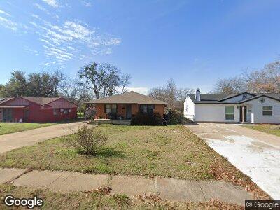
535 Power Dr Duncanville, TX 75116
Camp Wisdom West NeighborhoodEstimated Value: $266,225 - $292,000
3
Beds
2
Baths
2,116
Sq Ft
$130/Sq Ft
Est. Value
About This Home
This home is located at 535 Power Dr, Duncanville, TX 75116 and is currently estimated at $275,806, approximately $130 per square foot. 535 Power Dr is a home located in Dallas County with nearby schools including Central Elementary School, Glenn C. Hardin Intermediate School, and J. Herman Reed Middle School.
Ownership History
Date
Name
Owned For
Owner Type
Purchase Details
Closed on
Feb 2, 2001
Sold by
Huddleston Nathaniel B and Huddleston Deanna
Bought by
Robles Rudy and Robles Teresa
Current Estimated Value
Home Financials for this Owner
Home Financials are based on the most recent Mortgage that was taken out on this home.
Original Mortgage
$73,841
Interest Rate
7.13%
Mortgage Type
FHA
Purchase Details
Closed on
Jun 13, 1997
Sold by
Huddleston Mark and Huddleston Martha
Bought by
Huddleston Nathaniel B
Home Financials for this Owner
Home Financials are based on the most recent Mortgage that was taken out on this home.
Original Mortgage
$42,000
Interest Rate
9.99%
Create a Home Valuation Report for This Property
The Home Valuation Report is an in-depth analysis detailing your home's value as well as a comparison with similar homes in the area
Home Values in the Area
Average Home Value in this Area
Purchase History
| Date | Buyer | Sale Price | Title Company |
|---|---|---|---|
| Robles Rudy | -- | -- | |
| Huddleston Nathaniel B | -- | -- |
Source: Public Records
Mortgage History
| Date | Status | Borrower | Loan Amount |
|---|---|---|---|
| Open | Robles Teresa A | $77,140 | |
| Closed | Robles Rudy | $73,841 | |
| Previous Owner | Huddleston Nathaniel B | $42,000 | |
| Closed | Huddleston Nathaniel B | $13,200 |
Source: Public Records
Tax History Compared to Growth
Tax History
| Year | Tax Paid | Tax Assessment Tax Assessment Total Assessment is a certain percentage of the fair market value that is determined by local assessors to be the total taxable value of land and additions on the property. | Land | Improvement |
|---|---|---|---|---|
| 2023 | $1,728 | $293,090 | $40,000 | $253,090 |
| 2022 | $7,248 | $293,090 | $40,000 | $253,090 |
| 2021 | $4,200 | $159,540 | $30,000 | $129,540 |
| 2020 | $4,346 | $159,540 | $30,000 | $129,540 |
| 2019 | $3,948 | $134,990 | $24,000 | $110,990 |
| 2018 | $3,964 | $134,990 | $24,000 | $110,990 |
| 2017 | $3,075 | $104,770 | $19,000 | $85,770 |
| 2016 | $2,703 | $92,090 | $14,000 | $78,090 |
| 2015 | $2,248 | $91,100 | $14,000 | $77,100 |
| 2014 | $2,248 | $91,100 | $14,000 | $77,100 |
Source: Public Records
Map
Nearby Homes
- 711 Granada Dr
- 710 Granada Dr
- 618 E Cherry St
- 627 E Center Cir
- 643 Michaels Dr
- 819 Granada Dr
- 327 Carder St
- 611 Oriole Blvd Unit 1003
- 611 Oriole Blvd Unit 404
- 611 Oriole Blvd Unit 102
- 666 Lazy River Dr
- 646 E Fairmeadows Dr
- 610 Walnut St
- 619 Holly Ln
- 206 Mcmurry Ave
- 215 Mizell St
- 1330 Winding Trail
- 215 Merribrook Trail
- 318 Van Rowe Ave
- 315 W Orange St