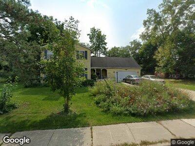
555 Hill St Downers Grove, IL 60515
Estimated Value: $888,381 - $1,211,000
--
Bed
--
Bath
3,112
Sq Ft
$333/Sq Ft
Est. Value
About This Home
This home is located at 555 Hill St, Downers Grove, IL 60515 and is currently estimated at $1,036,095, approximately $332 per square foot. 555 Hill St is a home located in DuPage County with nearby schools including Whittier Elementary School, Herrick Middle School, and Downer Grove North High School.
Ownership History
Date
Name
Owned For
Owner Type
Purchase Details
Closed on
Apr 7, 2000
Sold by
Volmer John A and Volmer Jeanne M
Bought by
Volmer John A and Volmer Jeanne M
Current Estimated Value
Purchase Details
Closed on
Jun 16, 1995
Sold by
Hyde James A and Hyde Kathleen A
Bought by
Volmer John A and Volmer Jeanne M
Home Financials for this Owner
Home Financials are based on the most recent Mortgage that was taken out on this home.
Original Mortgage
$60,000
Interest Rate
7.9%
Create a Home Valuation Report for This Property
The Home Valuation Report is an in-depth analysis detailing your home's value as well as a comparison with similar homes in the area
Home Values in the Area
Average Home Value in this Area
Purchase History
| Date | Buyer | Sale Price | Title Company |
|---|---|---|---|
| Volmer John A | -- | -- | |
| Volmer John A | $275,000 | Attorneys Title Guaranty Fun |
Source: Public Records
Mortgage History
| Date | Status | Borrower | Loan Amount |
|---|---|---|---|
| Open | Volmer John A | $110,000 | |
| Closed | Volmer John A | $80,000 | |
| Closed | Volmer John A | $54,000 | |
| Closed | Volmer John A | $60,000 |
Source: Public Records
Tax History Compared to Growth
Tax History
| Year | Tax Paid | Tax Assessment Tax Assessment Total Assessment is a certain percentage of the fair market value that is determined by local assessors to be the total taxable value of land and additions on the property. | Land | Improvement |
|---|---|---|---|---|
| 2023 | $15,834 | $274,370 | $122,340 | $152,030 |
| 2022 | $14,938 | $259,810 | $115,850 | $143,960 |
| 2021 | $13,984 | $256,850 | $114,530 | $142,320 |
| 2020 | $13,730 | $251,760 | $112,260 | $139,500 |
| 2019 | $13,304 | $241,560 | $107,710 | $133,850 |
| 2018 | $13,962 | $250,280 | $107,090 | $143,190 |
| 2017 | $13,529 | $240,840 | $103,050 | $137,790 |
| 2016 | $13,276 | $229,850 | $98,350 | $131,500 |
| 2015 | $13,150 | $216,250 | $92,530 | $123,720 |
| 2014 | $12,065 | $193,170 | $81,790 | $111,380 |
| 2013 | $11,821 | $192,270 | $81,410 | $110,860 |
Source: Public Records
Map
Nearby Homes
- 5253 Blodgett Ave
- 5213 Fairview Ave
- 325 2nd St
- 806 Randall St
- 4946 Douglas Rd Unit 202
- 5513 Fairview Ave
- 515 Austin St
- 5504 Lyman Ave
- 342 Maple Ave
- 5409 Webster St
- 4914 Prospect Ave
- 324 Maple Ave
- 4841 Prospect Ave
- 935 Burlington Ave Unit 403
- 5329 Main St Unit 502
- 5330 Main St
- 216 White Fawn Trail
- 5332 Lane Place
- 312 Prairie Ave
- 3 8th St