Estimated Value: $460,000 - $596,000
3
Beds
3
Baths
1,832
Sq Ft
$287/Sq Ft
Est. Value
About This Home
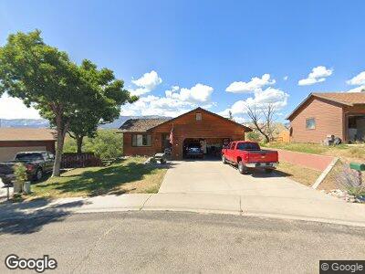
This home is located at 581 Mesa Ave, Rifle, CO 81650 and is currently estimated at $525,334, approximately $286 per square foot. 581 Mesa Ave is a home located in Garfield County with nearby schools including Graham Mesa Elementary School, Rifle Middle School, and Rifle High School.
Ownership History
Date
Name
Owned For
Owner Type
Purchase Details
Closed on
Aug 9, 2013
Sold by
Hatfield Fred D and Hatfield Marilyn I
Bought by
Kramp Donald R and Kramp Julie A
Current Estimated Value
Home Financials for this Owner
Home Financials are based on the most recent Mortgage that was taken out on this home.
Original Mortgage
$50,000
Interest Rate
4.49%
Mortgage Type
New Conventional
Purchase Details
Closed on
Oct 11, 2002
Sold by
Fenner Frederick R and Fenner Melanie A
Bought by
Hatfield Fred D and Hatfield Marilyn I
Home Financials for this Owner
Home Financials are based on the most recent Mortgage that was taken out on this home.
Original Mortgage
$162,400
Interest Rate
6.09%
Purchase Details
Closed on
Aug 13, 1999
Sold by
Walters Bradley E and Walters Jacqueline L
Bought by
Fenner Frederick R and Fenner Melanie A
Purchase Details
Closed on
Apr 8, 1992
Purchase Details
Closed on
Aug 27, 1990
Create a Home Valuation Report for This Property
The Home Valuation Report is an in-depth analysis detailing your home's value as well as a comparison with similar homes in the area
Home Values in the Area
Average Home Value in this Area
Purchase History
| Date | Buyer | Sale Price | Title Company |
|---|---|---|---|
| Kramp Donald R | $215,000 | Cwt | |
| Hatfield Fred D | $203,000 | -- | |
| Fenner Frederick R | $191,800 | -- | |
| -- | $9,500 | -- | |
| -- | $8,500 | -- |
Source: Public Records
Mortgage History
| Date | Status | Borrower | Loan Amount |
|---|---|---|---|
| Closed | Kramp Donald R | $50,000 | |
| Previous Owner | Hatfield Fred D | $145,000 | |
| Previous Owner | Hatfield Fred D | $162,400 | |
| Previous Owner | Fenner Frederick R | $161,300 |
Source: Public Records
Tax History Compared to Growth
Tax History
| Year | Tax Paid | Tax Assessment Tax Assessment Total Assessment is a certain percentage of the fair market value that is determined by local assessors to be the total taxable value of land and additions on the property. | Land | Improvement |
|---|---|---|---|---|
| 2024 | $2,194 | $28,770 | $5,640 | $23,130 |
| 2023 | $2,194 | $28,770 | $5,640 | $23,130 |
| 2022 | $1,663 | $23,230 | $5,210 | $18,020 |
| 2021 | $1,911 | $23,900 | $5,360 | $18,540 |
| 2020 | $1,515 | $20,710 | $3,150 | $17,560 |
| 2019 | $1,434 | $20,710 | $3,150 | $17,560 |
| 2018 | $1,354 | $19,130 | $2,950 | $16,180 |
| 2017 | $1,224 | $19,130 | $2,950 | $16,180 |
| 2016 | $969 | $17,150 | $2,870 | $14,280 |
| 2015 | $895 | $17,150 | $2,870 | $14,280 |
| 2014 | $558 | $10,620 | $1,950 | $8,670 |
Source: Public Records
Map
Nearby Homes
- 2420 Pioneer Way
- 2432 Pioneer Way
- 488 Crockett Cir
- 1165 Park Ave
- 125 E 9th St
- 216 E 1st St
- 1022 East Ave
- Tract 1 Whiteriver Ave
- TBD Howard Ave
- 46 Clarkson Ave
- 0 Mccarron Ct
- 450 E 10th St
- 0 Colorado 13
- 325 7th St S
- 1334 Clover Ct
- 1363 Clover Ct
- 200 W 20th St Unit C2
- 200 W 20th St Unit A142
- 200 W 20th St Unit E3
- 200 W 20th St Unit A140