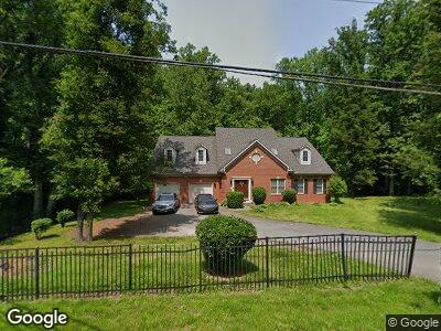
6114 Croom Station Rd Upper Marlboro, MD 20772
Queensland NeighborhoodEstimated Value: $714,000 - $785,000
--
Bed
3
Baths
3,157
Sq Ft
$236/Sq Ft
Est. Value
About This Home
This home is located at 6114 Croom Station Rd, Upper Marlboro, MD 20772 and is currently estimated at $745,515, approximately $236 per square foot. 6114 Croom Station Rd is a home located in Prince George's County with nearby schools including Marlton Elementary School, Gwynn Park Middle School, and Dr. Henry A. Wise Jr. High School.
Ownership History
Date
Name
Owned For
Owner Type
Purchase Details
Closed on
Dec 29, 2023
Sold by
Johnson Deanna
Bought by
Johnson Deanna G
Current Estimated Value
Home Financials for this Owner
Home Financials are based on the most recent Mortgage that was taken out on this home.
Original Mortgage
$318,482
Outstanding Balance
$304,335
Interest Rate
6.66%
Mortgage Type
New Conventional
Estimated Equity
$413,686
Purchase Details
Closed on
Jun 6, 2001
Sold by
Young Eula W
Bought by
Johnson Carl L and Johnson Beverly W
Create a Home Valuation Report for This Property
The Home Valuation Report is an in-depth analysis detailing your home's value as well as a comparison with similar homes in the area
Home Values in the Area
Average Home Value in this Area
Purchase History
| Date | Buyer | Sale Price | Title Company |
|---|---|---|---|
| Johnson Deanna G | -- | None Listed On Document | |
| Johnson Carl L | $64,900 | -- |
Source: Public Records
Mortgage History
| Date | Status | Borrower | Loan Amount |
|---|---|---|---|
| Open | Newrez Llc | $318,482 | |
| Previous Owner | Johnson Carl L | $369,000 | |
| Previous Owner | Johnson Carl L | $554,000 | |
| Previous Owner | Johnson Carl L | $388,000 | |
| Previous Owner | Johnson Carl L | $44,000 |
Source: Public Records
Tax History Compared to Growth
Tax History
| Year | Tax Paid | Tax Assessment Tax Assessment Total Assessment is a certain percentage of the fair market value that is determined by local assessors to be the total taxable value of land and additions on the property. | Land | Improvement |
|---|---|---|---|---|
| 2024 | $8,590 | $650,500 | $0 | $0 |
| 2023 | $8,178 | $588,400 | $0 | $0 |
| 2022 | $7,699 | $526,300 | $112,000 | $414,300 |
| 2021 | $7,452 | $523,100 | $0 | $0 |
| 2020 | $7,392 | $519,900 | $0 | $0 |
| 2019 | $7,287 | $516,700 | $109,600 | $407,100 |
| 2018 | $7,033 | $489,033 | $0 | $0 |
| 2017 | $6,824 | $461,367 | $0 | $0 |
| 2016 | -- | $433,700 | $0 | $0 |
| 2015 | $6,003 | $425,467 | $0 | $0 |
| 2014 | $6,003 | $417,233 | $0 | $0 |
Source: Public Records
Map
Nearby Homes
- 6109 Whittemore Ct
- 14409 Waynesford Dr
- 0 Robert Crain Hwy Unit MDPG2140262
- 0 Robert Crain Hwy Unit MDPG2116538
- 5802 Rocky Trail Way
- 6205 Curtis Rd
- 13201 Crestmar Ct
- 14129 Spring Branch Dr
- 13503 Old Marlboro Pike
- 5209 Mount Airy Ln
- 5109 Mapleshade Ln W
- 14200 Farnsworth Ln Unit 403
- 14264 Hampshire Hall Ct
- 14262 Hampshire Hall Ct
- 13900 Farnsworth Ln Unit 4403
- 4905 Colonel Addison Place
- 7000 Robert Crain Hwy
- 13900 Ascott Dr
- 4846 King John Way
- 13905 Fareham Ln