
646 Wiggins Mill Rd Townsend, DE 19734
About This Lot
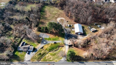
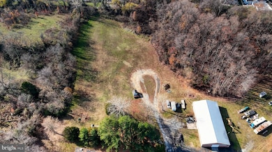
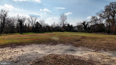
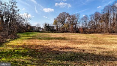
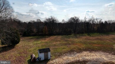
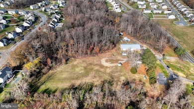
As of October 2024Public water and sewer hook ups and other utilities available on left. side of the property. This 2.9 acre parcel is getting divided into 3 parts and 2 are being sold for $200,000 each. Each lot will be APPROXIMATELY 0.90 OF AN ACRE. You are not buying almost 3 acres.

Property Details
Property Type
- Land
Est. Annual Taxes
- $1,487
Year Built
- 1949
Lot Details
- 2.93 Acre Lot
- Lot Dimensions are 165.00 x 694.70
- Property is zoned 25R1A
Schools
- Townsend Elementary School
- Everett Meredith Middle School
- Middletown High School
Utilities
- Public Hookup Available For Sewer
Community Details
- No Home Owners Association
Listing and Financial Details
- Tax Lot 185
- Assessor Parcel Number 25-001.00-185
Map
Home Values in the Area
Average Home Value in this Area
Property History
| Date | Event | Price | Change | Sq Ft Price |
|---|---|---|---|---|
| 10/22/2024 10/22/24 | Sold | $600,000 | +200.0% | $302 / Sq Ft |
| 10/08/2024 10/08/24 | Pending | -- | -- | -- |
| 11/28/2023 11/28/23 | For Sale | $200,000 | -- | $101 / Sq Ft |
Tax History
| Year | Tax Paid | Tax Assessment Tax Assessment Total Assessment is a certain percentage of the fair market value that is determined by local assessors to be the total taxable value of land and additions on the property. | Land | Improvement |
|---|---|---|---|---|
| 2024 | $1,663 | $44,300 | $10,700 | $33,600 |
| 2023 | $1,395 | $44,300 | $10,700 | $33,600 |
| 2022 | $1,393 | $44,300 | $10,700 | $33,600 |
| 2021 | $1,376 | $44,300 | $10,700 | $33,600 |
| 2020 | $1,360 | $44,300 | $10,700 | $33,600 |
| 2019 | $1,253 | $44,300 | $10,700 | $33,600 |
| 2018 | $0 | $44,300 | $10,700 | $33,600 |
| 2017 | $1,079 | $44,300 | $10,700 | $33,600 |
| 2016 | $1,079 | $44,300 | $10,700 | $33,600 |
| 2015 | $1,046 | $44,300 | $10,700 | $33,600 |
| 2014 | $1,044 | $44,300 | $10,700 | $33,600 |
Mortgage History
| Date | Status | Loan Amount | Loan Type |
|---|---|---|---|
| Previous Owner | $180,527 | VA | |
| Previous Owner | $180,800 | VA | |
| Previous Owner | $216,750 | Fannie Mae Freddie Mac |
Deed History
| Date | Type | Sale Price | Title Company |
|---|---|---|---|
| Deed | -- | None Listed On Document | |
| Deed | $8,500 | -- |
Source: Bright MLS
MLS Number: DENC2053026
APN: 25-001.00-185
Disclaimer: Certain information contained herein is derived from information provided by parties other than Homes.com. All information provided is deemed reliable, but is not guaranteed to be accurate and should be independently verified.
![]() The data relating to real estate for sale on this website appears in part through the BRIGHT Internet Data Exchange program, a voluntary cooperative exchange of property listing data between licensed real estate brokerage firms, and is provided by BRIGHT through a licensing agreement.
The data relating to real estate for sale on this website appears in part through the BRIGHT Internet Data Exchange program, a voluntary cooperative exchange of property listing data between licensed real estate brokerage firms, and is provided by BRIGHT through a licensing agreement.
Listing information is from various brokers who participate in the Bright MLS IDX program and not all listings may be visible on the site.
The property information being provided on or through the website is for the personal, non-commercial use of consumers and such information may not be used for any purpose other than to identify prospective properties consumers may be interested in purchasing.
Some properties which appear for sale on the website may no longer be available because they are for instance, under contract, sold or are no longer being offered for sale.
Property information displayed is deemed reliable but is not guaranteed.
Copyright 2025 Bright MLS, Inc.
- 1003 W Founds St
- 613 Taylor St
- 633 South St
- 100 Karins Blvd
- 116 Main St
- 17 Brook Ramble Ln
- 5756 Summit Bridge Rd
- 306 Coralroot Dr Unit CHA
- 306 Coralroot Dr Unit MON
- 306 Coralroot Dr Unit MER
- 306 Coralroot Dr Unit PEN
- 306 Coralroot Dr Unit FA II
- 303 Coralroot Dr
- 219 Leatherwood Rd
- 154 Pine Tree Rd
- 174 Pine Tree Rd
- 6147 Summit Bridge Rd
- 990 Caldwell Corner Rd
- 1081 Caldwell Corner Rd
- 5482 Summit Bridge Rd