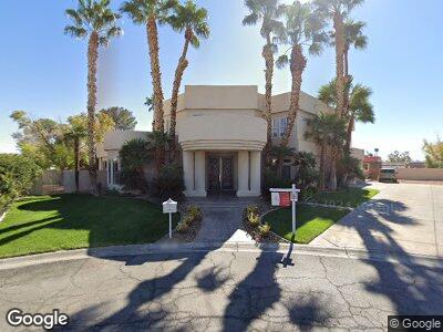
6705 Buckskin Ave Las Vegas, NV 89108
Woodcrest NeighborhoodEstimated Value: $859,132 - $1,040,000
6
Beds
5
Baths
3,799
Sq Ft
$251/Sq Ft
Est. Value
About This Home
This home is located at 6705 Buckskin Ave, Las Vegas, NV 89108 and is currently estimated at $953,533, approximately $250 per square foot. 6705 Buckskin Ave is a home located in Clark County with nearby schools including R.E. Tobler Elementary School, Irwin & Susan Molasky Junior High School, and Cheyenne High School.
Ownership History
Date
Name
Owned For
Owner Type
Purchase Details
Closed on
Feb 16, 1999
Sold by
Webb Michael B
Bought by
Webb Michael B and The Michael B Webb Living Trust
Current Estimated Value
Purchase Details
Closed on
Dec 16, 1994
Sold by
Wilson Mitchell E and Wilson Brenda K
Bought by
Hirales J Carlos and Hirales Veronica
Home Financials for this Owner
Home Financials are based on the most recent Mortgage that was taken out on this home.
Original Mortgage
$45,470
Interest Rate
9.29%
Mortgage Type
Seller Take Back
Create a Home Valuation Report for This Property
The Home Valuation Report is an in-depth analysis detailing your home's value as well as a comparison with similar homes in the area
Home Values in the Area
Average Home Value in this Area
Purchase History
| Date | Buyer | Sale Price | Title Company |
|---|---|---|---|
| Webb Michael B | -- | -- | |
| Hirales J Carlos | $50,500 | First American Title Company |
Source: Public Records
Mortgage History
| Date | Status | Borrower | Loan Amount |
|---|---|---|---|
| Previous Owner | Hirales J Carlos | $45,470 |
Source: Public Records
Tax History Compared to Growth
Tax History
| Year | Tax Paid | Tax Assessment Tax Assessment Total Assessment is a certain percentage of the fair market value that is determined by local assessors to be the total taxable value of land and additions on the property. | Land | Improvement |
|---|---|---|---|---|
| 2025 | $6,478 | $270,827 | $61,250 | $209,577 |
| 2024 | $5,998 | $270,827 | $61,250 | $209,577 |
| 2023 | $5,998 | $259,678 | $56,000 | $203,678 |
| 2022 | $5,554 | $230,491 | $43,750 | $186,741 |
| 2021 | $5,143 | $225,578 | $47,250 | $178,328 |
| 2020 | $4,773 | $215,497 | $38,500 | $176,997 |
| 2019 | $4,473 | $200,682 | $26,250 | $174,432 |
| 2018 | $4,268 | $196,626 | $28,000 | $168,626 |
| 2017 | $6,406 | $195,401 | $24,500 | $170,901 |
| 2016 | $3,994 | $192,014 | $21,000 | $171,014 |
| 2015 | $3,988 | $187,026 | $19,250 | $167,776 |
| 2014 | $3,871 | $114,560 | $17,500 | $97,060 |
Source: Public Records
Map
Nearby Homes
- 6687 Atwood Ave
- 6710 Rocking Horse Ave
- 6801 Atwood Ave
- 3425 Irv Marcus Dr
- 0 N Rainbow Blvd
- 6701 Willow River Ct
- 6632 Coastal Breeze Ct
- 3404 Winterhaven St Unit 204
- 3408 Winterhaven St Unit 204
- 3412 Winterhaven St Unit 101
- 3420 Winterhaven St Unit 202
- 6808 Elm Creek Dr Unit 203
- 6609 Pepperidge Way
- 3100 Garehime St
- 6440 Marrow Rd
- 6809 Cobre Azul Ave Unit 201
- 6836 Elm Creek Dr Unit 203
- 6700 Amarinta Ave Unit 104
- 3016 Light Wind Ct
- 6701 Dorita Ave Unit 202