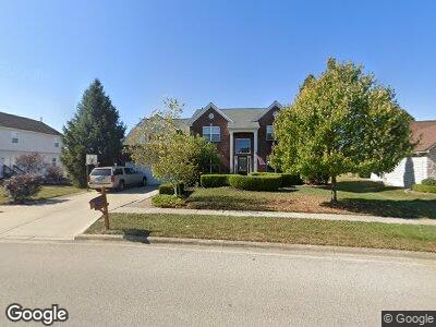
7042 Saint Ninians St Lewis Center, OH 43035
Orange NeighborhoodEstimated Value: $530,079 - $569,000
4
Beds
3
Baths
2,967
Sq Ft
$185/Sq Ft
Est. Value
About This Home
This home is located at 7042 Saint Ninians St, Lewis Center, OH 43035 and is currently estimated at $547,520, approximately $184 per square foot. 7042 Saint Ninians St is a home located in Delaware County with nearby schools including Alum Creek Elementary School, Olentangy Shanahan Middle School, and Olentangy High School.
Ownership History
Date
Name
Owned For
Owner Type
Purchase Details
Closed on
Oct 10, 2001
Sold by
Rockford Homes Inc
Bought by
Strawser Steven B and Strawser Kathleen L
Current Estimated Value
Home Financials for this Owner
Home Financials are based on the most recent Mortgage that was taken out on this home.
Original Mortgage
$212,800
Interest Rate
6.99%
Mortgage Type
New Conventional
Create a Home Valuation Report for This Property
The Home Valuation Report is an in-depth analysis detailing your home's value as well as a comparison with similar homes in the area
Home Values in the Area
Average Home Value in this Area
Purchase History
| Date | Buyer | Sale Price | Title Company |
|---|---|---|---|
| Strawser Steven B | $266,145 | -- |
Source: Public Records
Mortgage History
| Date | Status | Borrower | Loan Amount |
|---|---|---|---|
| Open | Strawser Steven B | $86,700 | |
| Open | Strawser Steven B | $309,400 | |
| Closed | Strawser Steven B | $302,975 | |
| Closed | Strawser Steven B | $83,600 | |
| Closed | Strawser Steven B | $271,800 | |
| Closed | Strawser Steven B | $27,000 | |
| Closed | Strawser Steven B | $232,900 | |
| Closed | Strawser Steven B | $56,000 | |
| Closed | Strawser Steven B | $212,800 |
Source: Public Records
Tax History Compared to Growth
Tax History
| Year | Tax Paid | Tax Assessment Tax Assessment Total Assessment is a certain percentage of the fair market value that is determined by local assessors to be the total taxable value of land and additions on the property. | Land | Improvement |
|---|---|---|---|---|
| 2024 | $7,927 | $142,490 | $29,230 | $113,260 |
| 2023 | $7,956 | $142,490 | $29,230 | $113,260 |
| 2022 | $9,163 | $133,630 | $22,050 | $111,580 |
| 2021 | $9,214 | $133,630 | $22,050 | $111,580 |
| 2020 | $9,258 | $133,630 | $22,050 | $111,580 |
| 2019 | $7,541 | $112,770 | $22,050 | $90,720 |
| 2018 | $7,568 | $112,770 | $22,050 | $90,720 |
| 2017 | $7,124 | $104,590 | $19,220 | $85,370 |
| 2016 | $7,449 | $104,590 | $19,220 | $85,370 |
| 2015 | $6,792 | $104,590 | $19,220 | $85,370 |
| 2014 | $6,881 | $104,590 | $19,220 | $85,370 |
| 2013 | $7,040 | $104,590 | $19,220 | $85,370 |
Source: Public Records
Map
Nearby Homes
- 2453 Alisons St
- 7040 S Old State Rd
- 6980 S Old State Rd
- 2020 Violet Ct
- 2343 Omaha Place
- 3024 Abbey Knoll Dr
- 2295 Bold Venture Dr
- 1626 Geranium Dr
- 7490 Twin Acorn Ct
- 3144 Abbey Knoll Dr
- 1610 Daffodil Place
- 2207 Pleasant Colony Dr
- 7799 Manorgate St
- 7976 Gladshire Blvd
- 3439 McCammon Chase Dr
- 1589 Summersweet Cir
- 2608 Pleasant Colony Dr
- 7962 Earldale Ct
- 3020 Nantucket Dr
- 3040 Nantucket Dr