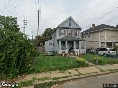
71 6th Ave Long Branch, NJ 07740
Estimated Value: $524,000 - $626,000
4
Beds
2
Baths
1,914
Sq Ft
$292/Sq Ft
Est. Value
About This Home
This home is located at 71 6th Ave, Long Branch, NJ 07740 and is currently estimated at $559,683, approximately $292 per square foot. 71 6th Ave is a home located in Monmouth County with nearby schools including Long Branch High School and Holy Trinity School.
Ownership History
Date
Name
Owned For
Owner Type
Purchase Details
Closed on
Dec 14, 2022
Sold by
Lobiondo James
Bought by
127 Brighton Llc
Current Estimated Value
Purchase Details
Closed on
Jul 7, 2011
Sold by
Stephens Jimmy and Stephens Veronica
Bought by
Biondo James Lo
Purchase Details
Closed on
Nov 18, 1996
Sold by
Gomez Placido
Bought by
Stephens Jimmy and Stephens Veronica
Home Financials for this Owner
Home Financials are based on the most recent Mortgage that was taken out on this home.
Original Mortgage
$79,000
Interest Rate
7.82%
Mortgage Type
FHA
Create a Home Valuation Report for This Property
The Home Valuation Report is an in-depth analysis detailing your home's value as well as a comparison with similar homes in the area
Home Values in the Area
Average Home Value in this Area
Purchase History
| Date | Buyer | Sale Price | Title Company |
|---|---|---|---|
| 127 Brighton Llc | -- | Pure Title | |
| Biondo James Lo | $200,000 | None Available | |
| Stephens Jimmy | $80,000 | -- |
Source: Public Records
Mortgage History
| Date | Status | Borrower | Loan Amount |
|---|---|---|---|
| Previous Owner | Stephens Jimmy | $79,000 |
Source: Public Records
Tax History Compared to Growth
Tax History
| Year | Tax Paid | Tax Assessment Tax Assessment Total Assessment is a certain percentage of the fair market value that is determined by local assessors to be the total taxable value of land and additions on the property. | Land | Improvement |
|---|---|---|---|---|
| 2024 | $6,072 | $414,700 | $113,500 | $301,200 |
| 2023 | $6,072 | $391,000 | $103,500 | $287,500 |
| 2022 | $6,171 | $339,800 | $86,500 | $253,300 |
| 2021 | $6,171 | $308,400 | $71,500 | $236,900 |
| 2020 | $6,354 | $304,000 | $68,500 | $235,500 |
| 2019 | $6,161 | $293,100 | $68,500 | $224,600 |
| 2018 | $6,021 | $284,800 | $68,500 | $216,300 |
| 2017 | $5,785 | $280,700 | $68,500 | $212,200 |
| 2016 | $5,764 | $285,200 | $78,500 | $206,700 |
| 2015 | $5,741 | $257,800 | $78,500 | $179,300 |
| 2014 | $5,340 | $252,700 | $93,500 | $159,200 |
Source: Public Records
Map
Nearby Homes
- 338 Wharburton Place
- 184 N 5th Ave
- 333-335 Joline Ave
- 127 7th Ave
- 52 Liberty St
- 399 Broadway
- 205 Sixth Ave Unit 3
- 230 Hamilton Ave
- 470 Joline Ave
- 42 Dudley St
- 227 Liberty St
- 145 Stokes Place
- 169 Chelsea Ave
- 167 Chelsea Ave
- 479 Hampton Ave
- 485 Hampton Ave
- 317 Morris Ave
- 140 Joline Ave
- 40 Seaview Ave Unit A
- 18 Seaview Ave