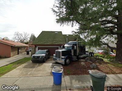
720 Blackwood St Sacramento, CA 95815
Woodlake NeighborhoodEstimated Value: $524,000 - $608,000
3
Beds
2
Baths
1,720
Sq Ft
$327/Sq Ft
Est. Value
About This Home
This home is located at 720 Blackwood St, Sacramento, CA 95815 and is currently estimated at $561,984, approximately $326 per square foot. 720 Blackwood St is a home located in Sacramento County with nearby schools including Woodlake Elementary School, Rio Tierra Junior High School, and Grant Union High School.
Ownership History
Date
Name
Owned For
Owner Type
Purchase Details
Closed on
Jan 6, 2000
Sold by
Perkins Michael J and Perkins Betty F
Bought by
Bolin Carl G
Current Estimated Value
Home Financials for this Owner
Home Financials are based on the most recent Mortgage that was taken out on this home.
Original Mortgage
$194,655
Interest Rate
6.07%
Purchase Details
Closed on
May 3, 1999
Sold by
Perkins Michael J and Perkins Betty F
Bought by
Perkins Michael J and Perkins Betty F
Purchase Details
Closed on
Jul 27, 1994
Sold by
Perkins Michael J and Perkins Betty F
Bought by
Perkins Michael J and Perkins Betty F
Create a Home Valuation Report for This Property
The Home Valuation Report is an in-depth analysis detailing your home's value as well as a comparison with similar homes in the area
Home Values in the Area
Average Home Value in this Area
Purchase History
| Date | Buyer | Sale Price | Title Company |
|---|---|---|---|
| Bolin Carl G | $205,000 | Chicago Title Co | |
| Perkins Michael J | -- | -- | |
| Perkins Michael J | -- | -- |
Source: Public Records
Mortgage History
| Date | Status | Borrower | Loan Amount |
|---|---|---|---|
| Open | Bolin Carl G | $100,000 | |
| Closed | Bolin Carl G | $50,000 | |
| Open | Bolin Carl G | $238,000 | |
| Closed | Perkins Michael J | $221,000 | |
| Previous Owner | Bolin Carl G | $194,655 | |
| Previous Owner | Perkins Michael J | $146,500 |
Source: Public Records
Tax History Compared to Growth
Tax History
| Year | Tax Paid | Tax Assessment Tax Assessment Total Assessment is a certain percentage of the fair market value that is determined by local assessors to be the total taxable value of land and additions on the property. | Land | Improvement |
|---|---|---|---|---|
| 2024 | $4,616 | $308,727 | $52,726 | $256,001 |
| 2023 | $5,933 | $302,675 | $51,693 | $250,982 |
| 2022 | $4,174 | $296,741 | $50,680 | $246,061 |
| 2021 | $4,535 | $290,924 | $49,687 | $241,237 |
| 2020 | $5,557 | $287,942 | $49,178 | $238,764 |
| 2019 | $3,414 | $282,297 | $48,214 | $234,083 |
| 2018 | $3,228 | $276,763 | $47,269 | $229,494 |
| 2017 | $3,322 | $271,338 | $46,343 | $224,995 |
| 2016 | $3,279 | $266,019 | $45,435 | $220,584 |
| 2015 | $3,087 | $262,024 | $44,753 | $217,271 |
| 2014 | $3,145 | $256,892 | $43,877 | $213,015 |
Source: Public Records
Map
Nearby Homes
- 611 Southgate Rd
- 2181 Cantalier St
- 575 Calvados Ave
- 2378 Cambridge St
- 715 Dixieanne Ave
- 554 El Camino Ave
- 509 Redwood Ave
- 624 Santiago Ave
- 2546 Del Paso Blvd
- 2313 Selma St
- 1500 El Monte Ave
- 600 Plaza Ave
- 1124 Lochbrae Rd
- 742 Bowles St
- 297 Redwood Ave
- 2562 Rio Linda Blvd
- 810 Lampasas Ave
- 1013 Frienza Ave
- 1021 Frienza Ave
- 2607 Beaumont St
