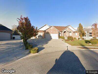
722 Andrea Cir Kaysville, UT 84037
West Kaysville NeighborhoodEstimated Value: $845,000 - $1,042,000
6
Beds
4
Baths
4,185
Sq Ft
$225/Sq Ft
Est. Value
About This Home
This home is located at 722 Andrea Cir, Kaysville, UT 84037 and is currently estimated at $943,573, approximately $225 per square foot. 722 Andrea Cir is a home located in Davis County with nearby schools including Kaysville Elementary School, Farmington High, and Centennial Junior High School.
Ownership History
Date
Name
Owned For
Owner Type
Purchase Details
Closed on
May 2, 2023
Sold by
Harris Margaret Alicia
Bought by
Margaret Harris Lining Trust
Current Estimated Value
Home Financials for this Owner
Home Financials are based on the most recent Mortgage that was taken out on this home.
Original Mortgage
$616,000
Outstanding Balance
$602,849
Interest Rate
5.88%
Mortgage Type
New Conventional
Estimated Equity
$270,131
Purchase Details
Closed on
Apr 27, 2023
Sold by
Margaret Harris Living Trust
Bought by
Larsen Andrew Mecham and Larsen Catherine Jean
Home Financials for this Owner
Home Financials are based on the most recent Mortgage that was taken out on this home.
Original Mortgage
$616,000
Outstanding Balance
$602,849
Interest Rate
5.88%
Mortgage Type
New Conventional
Estimated Equity
$270,131
Purchase Details
Closed on
Dec 17, 2021
Sold by
Harris Family Trust
Bought by
Margaret Harris Living Trust and Harris
Purchase Details
Closed on
Jan 7, 2020
Sold by
Harris Margaret L
Bought by
Harris Margaret L and The Harris Family Trust
Home Financials for this Owner
Home Financials are based on the most recent Mortgage that was taken out on this home.
Original Mortgage
$365,000
Interest Rate
3.6%
Purchase Details
Closed on
Nov 27, 2019
Sold by
Harris Margaret L and The Harris Family Trust
Bought by
Harris Margaret L
Home Financials for this Owner
Home Financials are based on the most recent Mortgage that was taken out on this home.
Original Mortgage
$365,000
Interest Rate
3.6%
Purchase Details
Closed on
Jul 26, 2018
Sold by
Harris Margaret L
Bought by
Harris Margaret L and Harris Family Trust
Purchase Details
Closed on
Apr 27, 2018
Sold by
Gunnell Steven L and Gunnell Kim L
Bought by
Harris Margaret L
Home Financials for this Owner
Home Financials are based on the most recent Mortgage that was taken out on this home.
Original Mortgage
$610,263
Interest Rate
4.44%
Mortgage Type
VA
Purchase Details
Closed on
Feb 14, 2005
Sold by
Lodder Homes Inc
Bought by
Gunnell Steven L and Gunnell Kim L
Home Financials for this Owner
Home Financials are based on the most recent Mortgage that was taken out on this home.
Original Mortgage
$129,000
Interest Rate
5.22%
Mortgage Type
New Conventional
Create a Home Valuation Report for This Property
The Home Valuation Report is an in-depth analysis detailing your home's value as well as a comparison with similar homes in the area
Home Values in the Area
Average Home Value in this Area
Purchase History
| Date | Buyer | Sale Price | Title Company |
|---|---|---|---|
| Larsen Andrew Mecham | -- | Cottonwood Title | |
| Margaret Harris Living Trust | -- | None Listed On Document | |
| Harris Margaret L | -- | None Available | |
| Harris Margaret L | -- | Inwest Title Service | |
| Harris Margaret L | -- | None Available | |
| Harris Margaret L | -- | Metro National Title | |
| Gunnell Steven L | -- | Aspen Title Insurance Agency |
Source: Public Records
Mortgage History
| Date | Status | Borrower | Loan Amount |
|---|---|---|---|
| Open | Larsen Andrew Mecham | $616,000 | |
| Previous Owner | Harris Margaret L | $365,000 | |
| Previous Owner | Harris Margaret L | $610,263 | |
| Previous Owner | Gunnell Steven L | $319,200 | |
| Previous Owner | Gunnell Steven L | $296,000 | |
| Previous Owner | Gunnell Steven L | $257,000 | |
| Previous Owner | Gunnell Steven L | $129,000 | |
| Previous Owner | Gunnell Steven L | $129,000 |
Source: Public Records
Tax History Compared to Growth
Tax History
| Year | Tax Paid | Tax Assessment Tax Assessment Total Assessment is a certain percentage of the fair market value that is determined by local assessors to be the total taxable value of land and additions on the property. | Land | Improvement |
|---|---|---|---|---|
| 2024 | $4,193 | $442,200 | $249,854 | $192,346 |
| 2023 | $4,166 | $827,000 | $429,977 | $397,023 |
| 2022 | $4,452 | $466,400 | $233,927 | $232,473 |
| 2021 | $3,993 | $627,000 | $277,026 | $349,974 |
| 2020 | $3,617 | $553,000 | $239,025 | $313,975 |
| 2019 | $3,110 | $467,000 | $230,174 | $236,826 |
| 2018 | $2,906 | $435,000 | $198,221 | $236,779 |
| 2016 | $2,572 | $202,345 | $101,211 | $101,134 |
| 2015 | $2,567 | $191,785 | $101,211 | $90,574 |
| 2014 | $2,857 | $217,316 | $75,123 | $142,193 |
| 2013 | -- | $167,209 | $54,016 | $113,193 |
Source: Public Records
Map
Nearby Homes
- 246 N Rock Loft Ridge Dr Unit 36-R
- 167 S Grandison E Unit 74-R
- 109 S Rock Loft Ridge Dr Unit 56-R
- 146 S Rock Loft Ridge Dr Unit 9-R
- 93 S Rock Loft Ridge Dr Unit 55-R
- 34 S Rock Loft Ridge Dr Unit 85-R
- 52 S Grandison Ct E Unit 83-R
- 786 S Angel St W Unit 6
- 190 N Rock Loft Ridge Dr Unit 40-R
- 96 S Rock Loft Ridge Dr Unit 12-R
- 28 N Rock Loft Ridge Dr Unit 46-R
- 22 S Rock Loft Ridge Dr Unit 16-R
- 127 N Rock Loft Ridge Dr E Unit 22-R
- 214 S Rock Loft Ridge Dr Unit 5-R
- 209 N Rock Loft Ridge E Unit 32-R
- 67 S Rock Loft Ridge Dr Unit 53-R
- 180 S Rock Loft Ridge Dr E Unit 7-R
- 382 W Parkway Dr
- 659 S Sunset Dr
- 80 S 400 W Unit 2