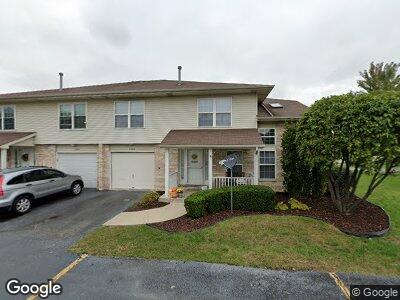
7253 White Ash Dr Unit 597253 Justice, IL 60458
Estimated Value: $240,020 - $279,000
2
Beds
1
Bath
7,687
Sq Ft
$34/Sq Ft
Est. Value
About This Home
This home is located at 7253 White Ash Dr Unit 597253, Justice, IL 60458 and is currently estimated at $261,255, approximately $33 per square foot. 7253 White Ash Dr Unit 597253 is a home located in Cook County with nearby schools including Frank A Brodnicki Elementary School and Argo Community High School.
Ownership History
Date
Name
Owned For
Owner Type
Purchase Details
Closed on
Mar 16, 1999
Sold by
Standard Bank & Trust Company
Bought by
Leonchik Muzyka Karen R
Current Estimated Value
Home Financials for this Owner
Home Financials are based on the most recent Mortgage that was taken out on this home.
Original Mortgage
$92,400
Interest Rate
7.1%
Create a Home Valuation Report for This Property
The Home Valuation Report is an in-depth analysis detailing your home's value as well as a comparison with similar homes in the area
Home Values in the Area
Average Home Value in this Area
Purchase History
| Date | Buyer | Sale Price | Title Company |
|---|---|---|---|
| Leonchik Muzyka Karen R | $139,000 | Ticor Title |
Source: Public Records
Mortgage History
| Date | Status | Borrower | Loan Amount |
|---|---|---|---|
| Closed | Leonchik Muzyka Karen R | $80,000 | |
| Closed | Leonchik Muzyka Karen R | $92,400 |
Source: Public Records
Tax History Compared to Growth
Tax History
| Year | Tax Paid | Tax Assessment Tax Assessment Total Assessment is a certain percentage of the fair market value that is determined by local assessors to be the total taxable value of land and additions on the property. | Land | Improvement |
|---|---|---|---|---|
| 2024 | $3,953 | $20,553 | $2,095 | $18,458 |
| 2023 | $3,953 | $20,553 | $2,095 | $18,458 |
| 2022 | $3,953 | $17,149 | $2,095 | $15,054 |
| 2021 | $3,816 | $17,149 | $2,095 | $15,054 |
| 2020 | $3,820 | $17,149 | $2,095 | $15,054 |
| 2019 | $3,090 | $14,706 | $1,913 | $12,793 |
| 2018 | $5,089 | $14,706 | $1,913 | $12,793 |
| 2017 | $5,045 | $14,706 | $1,913 | $12,793 |
| 2016 | $4,133 | $12,366 | $1,639 | $10,727 |
| 2015 | $4,044 | $12,366 | $1,639 | $10,727 |
| 2014 | $4,166 | $12,999 | $1,639 | $11,360 |
| 2013 | $4,248 | $14,409 | $1,639 | $12,770 |
Source: Public Records
Map
Nearby Homes
- 7250 Honey Locust Dr Unit 507
- 7434 Maplewood Dr
- 7136 S 86th Ave
- 8606 Huntington Ct
- 7431 Covington Place
- 7427 Covington Place
- 7433 Covington Place
- 7429 Covington Ave
- 8758 W 73rd St
- 7318 Blackstone Ave Unit 17
- 7940 W 71st St
- 8851 W 76th Place
- 7742 Oak Grove Ave
- 7631 Blazer Ave
- 6849 S Roberts Rd
- 7931 S 84th Ave
- 7546 S 78th Ct
- 7611 S 78th Ct
- 8024 S 84th Ave
- 6831 S 79th Ave