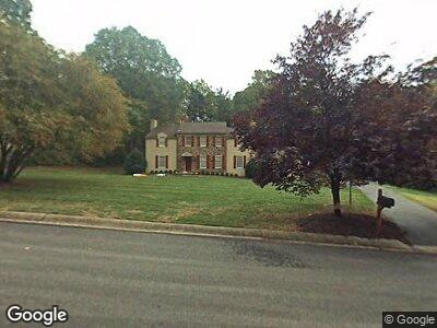
737 Camp Woods Rd Villanova, PA 19085
Estimated Value: $1,238,983 - $1,435,000
4
Beds
4
Baths
2,987
Sq Ft
$440/Sq Ft
Est. Value
About This Home
This home is located at 737 Camp Woods Rd, Villanova, PA 19085 and is currently estimated at $1,314,996, approximately $440 per square foot. 737 Camp Woods Rd is a home located in Delaware County with nearby schools including Ithan Elementary School, Radnor Middle School, and Radnor Senior High School.
Ownership History
Date
Name
Owned For
Owner Type
Purchase Details
Closed on
Jul 22, 2005
Sold by
Palmer Neil V and Palmer Martha S
Bought by
Mccloskey Brian T and Mccloskey Maria Della
Current Estimated Value
Home Financials for this Owner
Home Financials are based on the most recent Mortgage that was taken out on this home.
Original Mortgage
$300,000
Interest Rate
5.67%
Mortgage Type
Fannie Mae Freddie Mac
Create a Home Valuation Report for This Property
The Home Valuation Report is an in-depth analysis detailing your home's value as well as a comparison with similar homes in the area
Home Values in the Area
Average Home Value in this Area
Purchase History
| Date | Buyer | Sale Price | Title Company |
|---|---|---|---|
| Mccloskey Brian T | $864,000 | Trident Land Transfer Co |
Source: Public Records
Mortgage History
| Date | Status | Borrower | Loan Amount |
|---|---|---|---|
| Open | Mccloskey Brian T | $50,000 | |
| Open | Mccloskey Brian T | $268,955 | |
| Closed | Mccloskey Brian T | $300,000 |
Source: Public Records
Tax History Compared to Growth
Tax History
| Year | Tax Paid | Tax Assessment Tax Assessment Total Assessment is a certain percentage of the fair market value that is determined by local assessors to be the total taxable value of land and additions on the property. | Land | Improvement |
|---|---|---|---|---|
| 2024 | $14,038 | $694,330 | $225,760 | $468,570 |
| 2023 | $13,482 | $694,330 | $225,760 | $468,570 |
| 2022 | $13,335 | $694,330 | $225,760 | $468,570 |
| 2021 | $21,419 | $694,330 | $225,760 | $468,570 |
| 2020 | $13,260 | $381,160 | $128,000 | $253,160 |
| 2019 | $12,885 | $381,160 | $128,000 | $253,160 |
| 2018 | $12,633 | $381,160 | $0 | $0 |
| 2017 | $12,368 | $381,160 | $0 | $0 |
| 2016 | $2,092 | $381,160 | $0 | $0 |
| 2015 | $2,134 | $381,160 | $0 | $0 |
| 2014 | $2,092 | $381,160 | $0 | $0 |
Source: Public Records
Map
Nearby Homes
- 41 Greenwell Ln
- 0 Greenwell Ln
- 180 Abrahams Ln
- 746 Sproul Rd
- 635 S Ithan Ave
- 845 Colony Ct
- 658 Conestoga Rd
- 176 Abrahams Ln
- 447 Conestoga Rd
- 215 S Spring Mill Rd
- 353 Oak Terrace
- 705 Church Rd
- 853 Briarwood Rd
- 238 E Chelsea Cir Unit 238
- 221 S Aberdeen Ave
- 317 Iven Ave
- 253 Ithan Creek Rd
- 857 Hunt Rd
- 3111 Sawmill Rd Unit E
- 3111 Sawmill Rd Unit C