
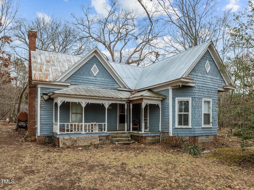
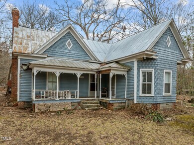
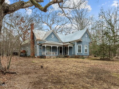

753 Smith Level Rd Chapel Hill, NC 27516
2
Beds
1
Bath
1,714
Sq Ft
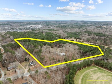
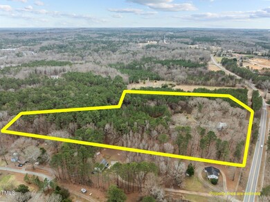
12.32
Acres
Highlights
- Horses Allowed On Property
- Property is near public transit
- Victorian Architecture
- Culbreth Middle School Rated A
- Wooded Lot
- Fireplace
About This Home
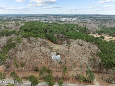
As of March 2025NOTICE: MULTIPLE OFFERS RECEIVED. SELLER ASKING FOR HIGHEST AND BEST BY 4:00 PM, TUESDAY, FEBRUARY 11, 2025 ===12.32 Acres, LOT 1, BOULDER HILL Subdivision; Directly across Smith Level Road from Carrboro High School; 1912 Victorian Gingerbread architecture home in very bad repair. No heat, no air, no appliances, there appears to be pest infestation and rotted wood in various places! (NO VALUE GIVEN FOR HOUSE AND OUTBUILDINGS); Price of 12.32 acres is solely valued on location as a building site in Boulder Hill per appraisal;
NOTE: TENANT LIVES IN HOUSE, WILL NOT ALLOW SHOWINGS INSIDE HOME AND ALL APPOINTMENS REQUIRE 24-HOURS NOTICE!! WITH VERY SPECIAL NOTICE, WE CAN SHOW INSIDE OF HOME UPON REQUEST. Sorry for the inconvenience.
Maps and disclosures are in TMLS Documents.
Home Details
Home Type
- Single Family
Est. Annual Taxes
- $4,521
Year Built
- Built in 1912
Lot Details
- 12.32 Acre Lot
- West Facing Home
- Wooded Lot
- Many Trees
- Garden
- Back and Front Yard
Home Design
- Victorian Architecture
- Brick or Stone Mason
- Stone Foundation
- Frame Construction
- Shingle Roof
- Wood Siding
- Shingle Siding
- Lead Paint Disclosure
- Stone
Interior Spaces
- 1,714 Sq Ft Home
- 1-Story Property
- Fireplace
Bedrooms and Bathrooms
- 2 Bedrooms
- 1 Full Bathroom
Parking
- 6 Parking Spaces
- 6 Open Parking Spaces
Outdoor Features
- Outbuilding
- Rain Gutters
Schools
- Carrboro Elementary School
- Grey Culbreth Middle School
- Carrboro High School
Utilities
- No Cooling
- No Heating
- Septic Tank
Additional Features
- Property is near public transit
- Horses Allowed On Property
Community Details
- Property has a Home Owners Association
- Boulder Hill Association
- Boulder Hill Subdivision
Listing and Financial Details
- Assessor Parcel Number 9777681283
Map
Create a Home Valuation Report for This Property
The Home Valuation Report is an in-depth analysis detailing your home's value as well as a comparison with similar homes in the area
Home Values in the Area
Average Home Value in this Area
Property History
| Date | Event | Price | Change | Sq Ft Price |
|---|---|---|---|---|
| 03/14/2025 03/14/25 | Sold | $626,500 | +25.3% | $366 / Sq Ft |
| 02/12/2025 02/12/25 | Pending | -- | -- | -- |
| 02/10/2025 02/10/25 | For Sale | $500,000 | -- | $292 / Sq Ft |
Source: Doorify MLS
Tax History
| Year | Tax Paid | Tax Assessment Tax Assessment Total Assessment is a certain percentage of the fair market value that is determined by local assessors to be the total taxable value of land and additions on the property. | Land | Improvement |
|---|---|---|---|---|
| 2024 | $4,659 | $392,500 | $327,400 | $65,100 |
| 2023 | $4,554 | $392,500 | $327,400 | $65,100 |
| 2022 | $4,480 | $392,500 | $327,400 | $65,100 |
| 2021 | $4,430 | $392,500 | $327,400 | $65,100 |
| 2020 | $4,536 | $376,700 | $318,200 | $58,500 |
| 2018 | $4,460 | $376,700 | $318,200 | $58,500 |
| 2017 | $3,651 | $376,700 | $318,200 | $58,500 |
| 2016 | $3,651 | $93,741 | $27,040 | $66,701 |
| 2015 | $3,651 | $93,741 | $27,040 | $66,701 |
| 2014 | -- | $93,741 | $27,040 | $66,701 |
Source: Public Records
Mortgage History
| Date | Status | Loan Amount | Loan Type |
|---|---|---|---|
| Previous Owner | $200,000 | Purchase Money Mortgage | |
| Closed | $200,000 | No Value Available |
Source: Public Records
Deed History
| Date | Type | Sale Price | Title Company |
|---|---|---|---|
| Warranty Deed | $626,500 | None Listed On Document | |
| Warranty Deed | $626,500 | None Listed On Document | |
| Warranty Deed | -- | None Available | |
| Warranty Deed | -- | None Available |
Source: Public Records
Similar Homes in the area
Source: Doorify MLS
MLS Number: 10075696
APN: 9777681283
Disclaimer: Certain information contained herein is derived from information provided by parties other than Homes.com. All information provided is deemed reliable, but is not guaranteed to be accurate and should be independently verified.
![]() Some IDX listings have been excluded from this IDX display. Brokers make an effort to deliver accurate information, but buyers should independently verify any information on which they will rely in a transaction. The listing broker shall not be responsible for any typographical errors, misinformation, or misprints, and they shall be held totally harmless from any damages arising from reliance upon this data. This data is provided exclusively for consumers’ personal, non-commercial use. Listings marked with an icon are provided courtesy of the Doorify MLS, Inc. of North Carolina, Internet Data Exchange Database. Closed (sold) listings may have been listed and/or sold by a real estate firm other than the firm(s) featured on this website. Closed data is not available until the sale of the property is recorded in the MLS. Home sale data is not an appraisal, CMA, competitive or comparative market analysis, or home valuation of any property. Copyright 2025 Doorify MLS, Inc. of North Carolina. All rights reserved.
Some IDX listings have been excluded from this IDX display. Brokers make an effort to deliver accurate information, but buyers should independently verify any information on which they will rely in a transaction. The listing broker shall not be responsible for any typographical errors, misinformation, or misprints, and they shall be held totally harmless from any damages arising from reliance upon this data. This data is provided exclusively for consumers’ personal, non-commercial use. Listings marked with an icon are provided courtesy of the Doorify MLS, Inc. of North Carolina, Internet Data Exchange Database. Closed (sold) listings may have been listed and/or sold by a real estate firm other than the firm(s) featured on this website. Closed data is not available until the sale of the property is recorded in the MLS. Home sale data is not an appraisal, CMA, competitive or comparative market analysis, or home valuation of any property. Copyright 2025 Doorify MLS, Inc. of North Carolina. All rights reserved.
Nearby Homes
- 102 Antler Point Rd
- 260 Culbreth Rd
- 107 Westside Dr
- 102 Westside Dr
- 303 Smith Level Rd Unit E32
- 415 Westbury Dr
- 417 Westbury Dr
- 113 Weatherhill Point
- 229 Rose Walk Ln
- 490 Boulder Point Dr
- 237 Abercorn Cir
- 52 N Rosebank Dr
- 562 Boulder Point Dr
- 201 Adams Way
- 403 Brookgreen Dr
- 507 Parkside Cir
- 315 Westbrook Dr
- 409 Parkside Cir
- 103 Friar Ln
- 124 Friar Ln