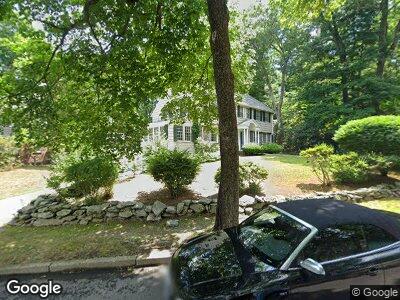
78 Bishopsgate Rd Newton Center, MA 02459
Newton Centre NeighborhoodEstimated Value: $2,393,827 - $2,951,000
4
Beds
4
Baths
3,490
Sq Ft
$740/Sq Ft
Est. Value
About This Home
This home is located at 78 Bishopsgate Rd, Newton Center, MA 02459 and is currently estimated at $2,582,707, approximately $740 per square foot. 78 Bishopsgate Rd is a home located in Middlesex County with nearby schools including Ward Elementary School, Mason Rice Elementary School, and Charles E Brown Middle School.
Ownership History
Date
Name
Owned For
Owner Type
Purchase Details
Closed on
Jul 14, 1992
Sold by
Piessens Willy F and Piessens Patricia
Bought by
Sockwell Samuel T and Murphy Elizabeth
Current Estimated Value
Home Financials for this Owner
Home Financials are based on the most recent Mortgage that was taken out on this home.
Original Mortgage
$416,000
Interest Rate
8.56%
Mortgage Type
Purchase Money Mortgage
Purchase Details
Closed on
Aug 4, 1988
Sold by
Kaden Stanley E
Bought by
Piessens Willy F
Home Financials for this Owner
Home Financials are based on the most recent Mortgage that was taken out on this home.
Original Mortgage
$300,000
Interest Rate
10.36%
Mortgage Type
Purchase Money Mortgage
Create a Home Valuation Report for This Property
The Home Valuation Report is an in-depth analysis detailing your home's value as well as a comparison with similar homes in the area
Home Values in the Area
Average Home Value in this Area
Purchase History
| Date | Buyer | Sale Price | Title Company |
|---|---|---|---|
| Sockwell Samuel T | $520,000 | -- | |
| Piessens Willy F | $525,000 | -- |
Source: Public Records
Mortgage History
| Date | Status | Borrower | Loan Amount |
|---|---|---|---|
| Open | Sockwell Samuel T | $175,000 | |
| Closed | Piessens Willy F | $416,000 | |
| Closed | Piessens Willy F | $416,000 | |
| Previous Owner | Piessens Willy F | $300,000 |
Source: Public Records
Tax History Compared to Growth
Tax History
| Year | Tax Paid | Tax Assessment Tax Assessment Total Assessment is a certain percentage of the fair market value that is determined by local assessors to be the total taxable value of land and additions on the property. | Land | Improvement |
|---|---|---|---|---|
| 2025 | $23,157 | $2,363,000 | $1,725,900 | $637,100 |
| 2024 | $22,391 | $2,294,200 | $1,675,600 | $618,600 |
| 2023 | $21,326 | $2,094,900 | $1,293,000 | $801,900 |
| 2022 | $20,406 | $1,939,700 | $1,197,200 | $742,500 |
| 2021 | $5,386 | $1,829,900 | $1,129,400 | $700,500 |
| 2020 | $5,174 | $1,829,900 | $1,129,400 | $700,500 |
| 2019 | $18,565 | $1,776,600 | $1,096,500 | $680,100 |
| 2018 | $4,627 | $1,658,100 | $999,100 | $659,000 |
| 2017 | $4,334 | $1,564,200 | $942,500 | $621,700 |
| 2016 | $16,636 | $1,461,900 | $880,800 | $581,100 |
| 2015 | $15,863 | $1,366,300 | $823,200 | $543,100 |
Source: Public Records
Map
Nearby Homes
- 9 The Ledges Rd
- 41 Edge Hill Rd
- 67 Prentice Rd
- 87 Hammond St
- 96 Monadnock Rd
- 101 Hammond St
- 145 Warren St Unit 5
- 145 Warren St Unit C
- 145 Warren St Unit 1
- 12 Garner St
- 11 Warren Terrace Unit 2
- 21 Francis St Unit 23
- 34 Hammond St
- 303 Ward St
- 131 Sumner St
- 154 Langley Rd Unit A
- 30 Sumner St Unit 3
- 254 Commonwealth Ave
- 56 W Boulevard Rd
- 16 Overlook Park