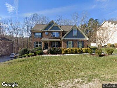
8887 Bakersfield Dr Kernersville, NC 27284
Oak Ridge NeighborhoodEstimated Value: $638,963 - $679,000
4
Beds
4
Baths
4,248
Sq Ft
$156/Sq Ft
Est. Value
About This Home
This home is located at 8887 Bakersfield Dr, Kernersville, NC 27284 and is currently estimated at $662,741, approximately $156 per square foot. 8887 Bakersfield Dr is a home with nearby schools including Colfax Elementary School, Northwest Guilford Middle School, and Northwest Guilford High School.
Ownership History
Date
Name
Owned For
Owner Type
Purchase Details
Closed on
Aug 16, 2018
Sold by
Mabie Robert and Mabie Gina
Bought by
Raike Anthony D and Raike Mary M
Current Estimated Value
Home Financials for this Owner
Home Financials are based on the most recent Mortgage that was taken out on this home.
Original Mortgage
$216,500
Outstanding Balance
$189,959
Interest Rate
4.5%
Mortgage Type
New Conventional
Estimated Equity
$472,782
Purchase Details
Closed on
Mar 15, 2017
Sold by
Dr Horton Inc
Bought by
Mabie Robert and Mabie Gina
Home Financials for this Owner
Home Financials are based on the most recent Mortgage that was taken out on this home.
Original Mortgage
$424,976
Interest Rate
4.19%
Mortgage Type
VA
Purchase Details
Closed on
Nov 24, 2015
Bought by
Dr Horton Inc
Create a Home Valuation Report for This Property
The Home Valuation Report is an in-depth analysis detailing your home's value as well as a comparison with similar homes in the area
Home Values in the Area
Average Home Value in this Area
Purchase History
| Date | Buyer | Sale Price | Title Company |
|---|---|---|---|
| Raike Anthony D | $416,500 | None Available | |
| Mabie Robert | $411,500 | None Available | |
| Dr Horton Inc | -- | -- |
Source: Public Records
Mortgage History
| Date | Status | Borrower | Loan Amount |
|---|---|---|---|
| Open | Raike Anthony D | $216,500 | |
| Previous Owner | Mabie Robert | $424,976 |
Source: Public Records
Tax History Compared to Growth
Tax History
| Year | Tax Paid | Tax Assessment Tax Assessment Total Assessment is a certain percentage of the fair market value that is determined by local assessors to be the total taxable value of land and additions on the property. | Land | Improvement |
|---|---|---|---|---|
| 2023 | $3,883 | $448,200 | $80,000 | $368,200 |
| 2022 | $3,807 | $448,200 | $80,000 | $368,200 |
| 2021 | $3,382 | $390,300 | $55,000 | $335,300 |
| 2020 | $3,382 | $390,300 | $55,000 | $335,300 |
| 2019 | $3,382 | $390,300 | $0 | $0 |
| 2018 | $3,365 | $390,300 | $0 | $0 |
| 2017 | $3,365 | $390,300 | $0 | $0 |
| 2016 | -- | $0 | $0 | $0 |
Source: Public Records
Map
Nearby Homes
- 8810 Phillips Farm Rd
- 9131 County Line Rd
- 2307 Barn Swallow Rd
- 1651 Lazy Fox Ln Unit 38
- 1653 Lazy Fox Ln Unit 37
- 1655 Lazy Fox Ln Unit 36
- 1631 Lazy Fox Ln Unit 46
- 1661 Lazy Fox Ln Unit 33
- 1663 Lazy Fox Ln Unit 32
- 1652 Lazy Fox Ln Unit 22
- 1654 Lazy Fox Ln Unit 23
- 1096 Hollow Creek Ln Unit 16
- 1095 Hollow Creek Ln Unit 11
- 1081 Luna Creek Ct Unit 27
- 1092 Hollow Creek Ln Unit 15
- 1085 Luna Creek Ct Unit 26
- 1620 Lazy Fox Ln Unit 6
- 1614 Lazy Fox Ln Unit 4
- 1088 Hollow Creek Ln Unit 14
- 1610 Lazy Fox Ln Unit 3