
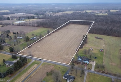
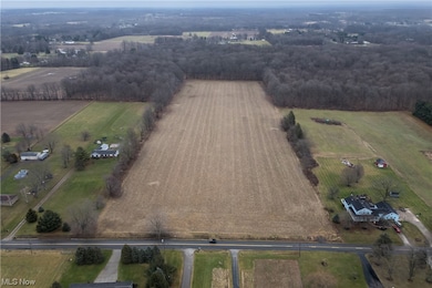
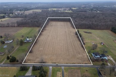
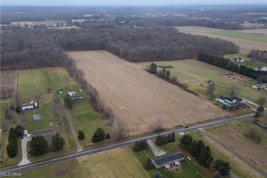
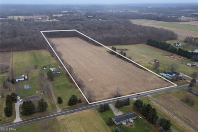
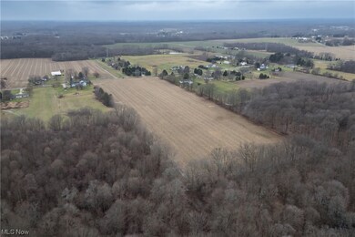
Lot 12 New Milford (15 73ac) Rootstown, OH 44272
Estimated payment $1,854/month
Highlights
- 15.73 Acre Lot
- No HOA
- Public Transportation
About This Lot
15.7 acres located in Beautiful Rootstown Ohio nestled on New Milford Road. It has approximately 480' frontage and could be more than one lot if you choose to split. It would make a beautiful building lot and is close to the College of Medicine, Kent State, and is in the middle between Akron and Youngstown making your commute a breeze. It is country living at its best. Come see for yourself! This land is located between 3176 and 3118 New Milford Road, Rootstown.
Listing Agent
Howard Hanna Brokerage Email: susanwhite@howardhanna.com 330-388-3543 License #443102

Property Details
Property Type
- Land
Est. Annual Taxes
- $249
Lot Details
- 15.73 Acre Lot
- Lot Dimensions are 480x1469
- Property fronts a county road
Utilities
- Water Not Available
- Sewer Not Available
Listing and Financial Details
- Assessor Parcel Number 32-012-00-00-001-000
Community Details
Overview
- No Home Owners Association
- Rootstown Subdivision
Amenities
- Public Transportation
Map
Home Values in the Area
Average Home Value in this Area
Tax History
| Year | Tax Paid | Tax Assessment Tax Assessment Total Assessment is a certain percentage of the fair market value that is determined by local assessors to be the total taxable value of land and additions on the property. | Land | Improvement |
|---|---|---|---|---|
| 2024 | $502 | $47,500 | $47,500 | -- |
| 2023 | $250 | $34,860 | $34,860 | $0 |
| 2022 | $249 | $34,860 | $34,860 | $0 |
| 2021 | $251 | $34,860 | $34,860 | $0 |
| 2020 | $364 | $33,220 | $33,220 | $0 |
| 2019 | $366 | $33,220 | $33,220 | $0 |
| 2018 | $531 | $34,580 | $34,580 | $0 |
| 2017 | $531 | $34,580 | $34,580 | $0 |
| 2016 | $531 | $34,580 | $34,580 | $0 |
| 2015 | $537 | $34,580 | $34,580 | $0 |
| 2014 | $276 | $34,580 | $34,580 | $0 |
| 2013 | $274 | $34,580 | $34,580 | $0 |
Property History
| Date | Event | Price | Change | Sq Ft Price |
|---|---|---|---|---|
| 01/24/2025 01/24/25 | Price Changed | $329,000 | -16.7% | -- |
| 10/21/2024 10/21/24 | Price Changed | $394,900 | +1.3% | -- |
| 01/12/2024 01/12/24 | For Sale | $389,900 | -- | -- |
Deed History
| Date | Type | Sale Price | Title Company |
|---|---|---|---|
| Fiduciary Deed | $150,000 | -- | |
| No Value Available | -- | -- | |
| Interfamily Deed Transfer | -- | None Available | |
| Interfamily Deed Transfer | -- | None Available |
Mortgage History
| Date | Status | Loan Amount | Loan Type |
|---|---|---|---|
| Previous Owner | -- | No Value Available |
Source: MLS Now (Howard Hanna)
MLS Number: 5010939
APN: 32-012-00-00-001-000
Disclaimer: Certain information contained herein is derived from information provided by parties other than Homes.com. All information provided is deemed reliable, but is not guaranteed to be accurate and should be independently verified.
![]() Certain information contained herein is derived from information provided by parties other than Homes.com. All information provided is deemed reliable, but is not guaranteed to be accurate and should be independently verified.
Certain information contained herein is derived from information provided by parties other than Homes.com. All information provided is deemed reliable, but is not guaranteed to be accurate and should be independently verified.
- Lot 3 New Milford (5 33 Ac)
- Lot 2 New Milford (5 33 Ac)
- Lot 1 New Milford (5 33 Ac)
- 3831 Cook Rd
- 5253 Bassett Rd
- 4121 New Milford Rd
- 3021 Hartville Rd
- 0 Ohio 44
- VL New Milford Rd
- 4273 Industry Rd
- 0 Lynn Rd Unit 5110102
- 0 Tallmadge Unit 5114872
- 0 Tallmadge Rd Unit 5096576
- 2236 Hartville Rd
- 4324 Abbey Ln
- 4426 Industry Rd
- 1746 State Route 44
- 1696 State Route 44
- 4759 Valley Hills Dr
- 0 Moff Rd Unit 5113378