
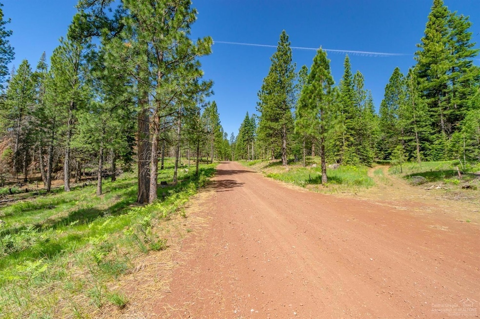


Lot-500 Forest Service Loop Unit 1030 Rd Sisters, OR 97759
Estimated payment $7,066/month
Total Views
20,047
316
Acres
$3,953
Price per Acre
13,773,670
Sq Ft Lot
Highlights
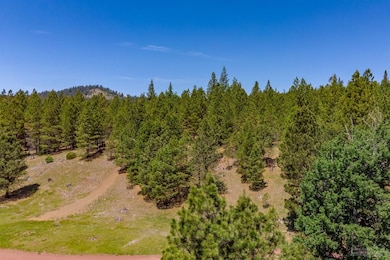
- 316.2 Acre Lot
- Mountain View
- Timber
- Sisters Elementary School Rated A-
- No HOA
About This Lot
Perfect for outdoor enthusiasts, secluded retreat, only 45 minutes to three world class fishing locations: Deschutes, Metolius, McKenzie & the many lakes that are accessible within a few miles radius. Just mintues away to the Pacific Crest Trail.
Property Details
Property Type
- Land
Est. Annual Taxes
- $1,069
Lot Details
- 316.2 Acre Lot
- Property is zoned FS, FS
Property Views
- Mountain
- Territorial
Schools
- Sisters Elementary School
- Sisters Middle School
- Sisters High School
Farming
- Timber
Community Details
- No Home Owners Association
Listing and Financial Details
- Assessor Parcel Number 144547
Map
Create a Home Valuation Report for This Property
The Home Valuation Report is an in-depth analysis detailing your home's value as well as a comparison with similar homes in the area
Home Values in the Area
Average Home Value in this Area
Property History
| Date | Event | Price | Change | Sq Ft Price |
|---|---|---|---|---|
| 08/07/2023 08/07/23 | For Sale | $1,250,000 | -- | -- |
Source: Southern Oregon MLS
Similar Property in Sisters, OR
Source: Southern Oregon MLS
MLS Number: 220169228
Disclaimer: Certain information contained herein is derived from information provided by parties other than Homes.com. All information provided is deemed reliable, but is not guaranteed to be accurate and should be independently verified.
![]() © 2025 Oregon Datashare (KCAR | MLSCO | SOMLS). All rights reserved. The data relating to real estate for sale on this web site comes in part from the Internet Data Exchange Program of the Oregon Datashare. Real estate listings held by IDX Brokerage firms other than Ten-X are marked with the Internet Data Exchange logo or the Internet Data Exchange thumbnail logo and detailed information about them includes the name of the listing Brokers. Information provided is for consumers' personal, non-commercial use and may not be used for any purpose other than to identify prospective properties the viewer may be interested in purchasing. The consumer will not copy, retransmit nor redistribute any of the content from this website. Information provided is deemed reliable, but not guaranteed.
© 2025 Oregon Datashare (KCAR | MLSCO | SOMLS). All rights reserved. The data relating to real estate for sale on this web site comes in part from the Internet Data Exchange Program of the Oregon Datashare. Real estate listings held by IDX Brokerage firms other than Ten-X are marked with the Internet Data Exchange logo or the Internet Data Exchange thumbnail logo and detailed information about them includes the name of the listing Brokers. Information provided is for consumers' personal, non-commercial use and may not be used for any purpose other than to identify prospective properties the viewer may be interested in purchasing. The consumer will not copy, retransmit nor redistribute any of the content from this website. Information provided is deemed reliable, but not guaranteed.
Nearby Homes
- 471 W Cascade Ave
- 342 W Main Ave
- 952 W Mckenzie Hwy Unit Lot 57
- 495 N Pine St Unit Lot 156
- 475 N Pine St Unit 158
- 574 W Jefferson Ave
- 732 W View Loop
- 535 N Pine St Unit 106
- 375 W Washington Ave
- 545 N Pine St Unit 107
- 506 W Sapling Ln Unit Lot 46
- 355 S Jefferson Way
- 285 W Washington Ave
- 356 W Jefferson Ave
- 595 N Pine St Unit Lot 110
- 517 W Jefferson Ave Unit 5
- 504 Sisters Park Dr Unit Lot 102
- 719 W Canopy Way Unit Lot 4
- 601 N Sisters Woodlands Way Unit Lot 10
- 709 W Canopy Way Unit Lot 5