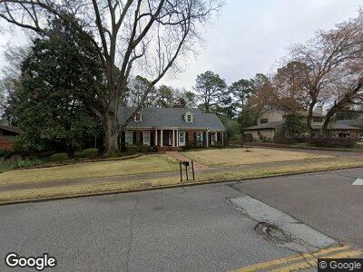
150 S Grove Park Rd Memphis, TN 38117
Audubon Park NeighborhoodEstimated Value: $567,081 - $726,000
7
Beds
4
Baths
5,044
Sq Ft
$129/Sq Ft
Est. Value
About This Home
This home is located at 150 S Grove Park Rd, Memphis, TN 38117 and is currently estimated at $651,020, approximately $129 per square foot. 150 S Grove Park Rd is a home located in Shelby County with nearby schools including White Station Elementary School, White Station High, and White Station Middle.
Ownership History
Date
Name
Owned For
Owner Type
Purchase Details
Closed on
Aug 24, 2023
Sold by
Hammond Evelyn Fondren
Bought by
Hammond Living Trust and Hammond
Current Estimated Value
Purchase Details
Closed on
Jun 1, 2014
Sold by
Fondren William Merle and Fondren Hammond Evelyn
Bought by
Fondren Hammond Evelyn
Purchase Details
Closed on
Nov 15, 2006
Sold by
Fondren Evelyn B
Bought by
Fondren Evelyn Baird and Evelyn Baird Fondren Revocable Living Tr
Create a Home Valuation Report for This Property
The Home Valuation Report is an in-depth analysis detailing your home's value as well as a comparison with similar homes in the area
Home Values in the Area
Average Home Value in this Area
Purchase History
| Date | Buyer | Sale Price | Title Company |
|---|---|---|---|
| Hammond Living Trust | -- | None Listed On Document | |
| Fondren Hammond Evelyn | -- | None Available | |
| Fondren Evelyn Baird | -- | None Available |
Source: Public Records
Mortgage History
| Date | Status | Borrower | Loan Amount |
|---|---|---|---|
| Previous Owner | Hammond Harold Glenn | $200,000 | |
| Previous Owner | Hammond Evelyn F | $50,000 |
Source: Public Records
Tax History Compared to Growth
Tax History
| Year | Tax Paid | Tax Assessment Tax Assessment Total Assessment is a certain percentage of the fair market value that is determined by local assessors to be the total taxable value of land and additions on the property. | Land | Improvement |
|---|---|---|---|---|
| 2024 | -- | $125,800 | $38,050 | $87,750 |
| 2023 | $7,663 | $125,800 | $38,050 | $87,750 |
| 2022 | $7,663 | $125,800 | $38,050 | $87,750 |
| 2021 | $7,753 | $125,800 | $38,050 | $87,750 |
| 2020 | $7,521 | $103,800 | $38,050 | $65,750 |
| 2019 | $7,342 | $101,325 | $38,050 | $63,275 |
| 2018 | $7,342 | $101,325 | $38,050 | $63,275 |
| 2017 | $4,164 | $101,325 | $38,050 | $63,275 |
| 2016 | $4,552 | $104,175 | $0 | $0 |
| 2014 | $4,552 | $104,175 | $0 | $0 |
Source: Public Records
Map
Nearby Homes
- 196 E Cherry Cir
- 4679 Walnut Grove Rd
- 45 Norwal Rd
- 427 S Perkins Rd Unit 427-2
- 4723 Gwynne Rd
- 155 Cherry Rd
- 135 Cherry Rd
- 272 S Perkins Rd
- 4654 Hemlock Ln
- 4348 Gwynne Rd
- 320 S Grove Park Rd
- 4772 Gwynne Rd
- 344 Perkins Extension
- 66 Wychewood Dr
- 4354 Walnut Grove Rd
- 4411 Normandy Rd
- 255 W Cherry Cir
- 4276 Montrose Dr
- 4870 Gwynne Rd
- 4723 Normandy Ln