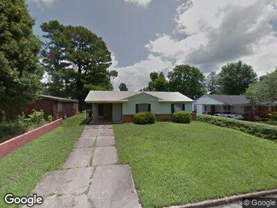
4274 Deerland St Memphis, TN 38109
Westwood NeighborhoodEstimated Value: $62,000 - $81,000
3
Beds
1
Bath
952
Sq Ft
$76/Sq Ft
Est. Value
About This Home
This home is located at 4274 Deerland St, Memphis, TN 38109 and is currently estimated at $72,009, approximately $75 per square foot. 4274 Deerland St is a home located in Shelby County with nearby schools including Levi Elementary School, Chickasaw Middle School, and Westwood High School.
Ownership History
Date
Name
Owned For
Owner Type
Purchase Details
Closed on
Feb 1, 2021
Sold by
Vb One Llc
Bought by
Vb Two Llc
Current Estimated Value
Purchase Details
Closed on
Feb 28, 2019
Sold by
Munn Floyd
Bought by
Vb One Llc
Purchase Details
Closed on
Nov 21, 2012
Sold by
Peterson Alisa
Bought by
Munn Floyd
Purchase Details
Closed on
Jan 4, 2007
Sold by
Peterson Alisa
Bought by
Peterson Alisa and Munn Floyd Lewis
Purchase Details
Closed on
Sep 28, 2006
Sold by
Munn Floyd Lewis
Bought by
Peterson Alisa
Purchase Details
Closed on
Sep 20, 2006
Sold by
First Tennessee Bank Na
Bought by
Munn Floyd Lewis
Purchase Details
Closed on
Nov 28, 2005
Sold by
Yarbrough Rubbie Lee and Walker Catherine A
Bought by
First Tennessee Bank Na
Create a Home Valuation Report for This Property
The Home Valuation Report is an in-depth analysis detailing your home's value as well as a comparison with similar homes in the area
Home Values in the Area
Average Home Value in this Area
Purchase History
| Date | Buyer | Sale Price | Title Company |
|---|---|---|---|
| Vb Two Llc | -- | None Available | |
| Vb One Llc | $37,000 | Total Title Services | |
| Munn Floyd | -- | None Available | |
| Peterson Alisa | -- | None Available | |
| Peterson Alisa | -- | None Available | |
| Munn Floyd Lewis | $30,000 | Usa Title & Escrow Inc | |
| First Tennessee Bank Na | $32,524 | -- |
Source: Public Records
Mortgage History
| Date | Status | Borrower | Loan Amount |
|---|---|---|---|
| Previous Owner | Yarbrough Rubbie Lee | $14,000 |
Source: Public Records
Tax History Compared to Growth
Tax History
| Year | Tax Paid | Tax Assessment Tax Assessment Total Assessment is a certain percentage of the fair market value that is determined by local assessors to be the total taxable value of land and additions on the property. | Land | Improvement |
|---|---|---|---|---|
| 2024 | $401 | $11,825 | $2,100 | $9,725 |
| 2023 | $720 | $11,825 | $2,100 | $9,725 |
| 2022 | $720 | $11,825 | $2,100 | $9,725 |
| 2021 | $856 | $11,825 | $2,100 | $9,725 |
| 2020 | $817 | $11,275 | $2,100 | $9,175 |
| 2019 | $360 | $11,275 | $2,100 | $9,175 |
| 2018 | $360 | $11,275 | $2,100 | $9,175 |
| 2017 | $369 | $11,275 | $2,100 | $9,175 |
| 2016 | $458 | $10,475 | $0 | $0 |
| 2014 | $458 | $10,475 | $0 | $0 |
Source: Public Records
Map
Nearby Homes
- 749 Ledbetter Ave
- 648 Mohawk Ave
- 648 Pawnee Ave
- 436 Western Park Dr
- 4335 Ford Rd
- 0 Ford Rd
- 530 W Raines Rd
- 896 Leacrest Ave
- 1307 W Raines Rd
- 4014 Oakshire Cove
- 4010 Oakshire St
- 686 Westview Rd
- 4141 Archer Cove
- 1010 Leacrest Ave
- 975 Norfleet Ave
- 3945 Oakshire St
- 3981 Hammett Dr
- 781 W Levi Rd
- 4658 Honeysuckle Ln
- 330 Granville Ave